The Western Hemisphere. General term for the Americas following their discovery by Europeans, thus setting them in contradistinction to the Old World of Africa, Europe, and Asia.
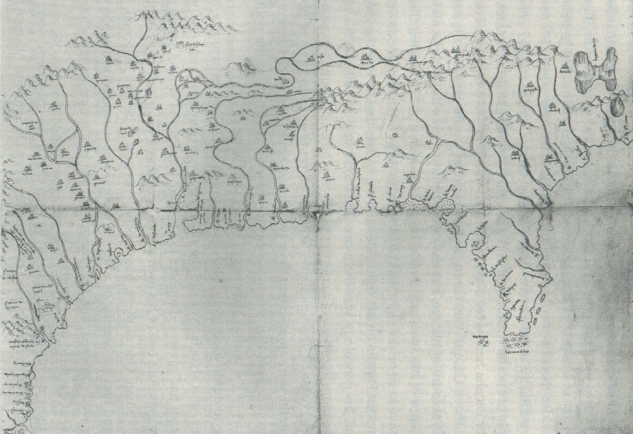
The original map exists, and shows corrections.
It would be nice to have it spectrally imaged by the team from BYU, so that the corrections and anything else could be better seen.
The same thing goes for the early colonial Hughe's map of the area.
On this map, "mabilla" is indicated by Tuscaloosa. Excuse my transcription here, but the lettering is too small to see in this image.
Last edited by E.P. Grondine on Fri Dec 26, 2014 2:10 pm, edited 2 times in total.
Notice that on the map the ApFallya are referred to as Pafalaya, Mabilla as Tuscaluza.
(Spellings just for use here. The letters can be seen much better on the original.)
The Pafalaya are likely shown on the wrong side of the Tombigbee River, but without checking Linecum...
After the battle, DeSoto et al took the Chief of the Fallaya captive.
I need to check the spanish original to see if they "took" canoes from Apfallaya, or if the canoes used to cross at Mokulisha were "taken" at Mokulisha from there.
The latter seems unlikely, as surely the Choctaw would not have left them behind for the Spanish to use.
Last edited by E.P. Grondine on Thu Feb 26, 2015 8:16 pm, edited 1 time in total.
I want to start this post by suggesting to the MOWA Choctaw that they stop fooling with BIA recognition and simply file a suit against the US Government for a couple of hundred million for the criminal actions of their agent William Wells.
Returning to the analysis of the Spanish accounts -
The "Hattak Falaya Hosh" "Division of the Long People" were most likely the original inhabitants of "Oktak Falaya", the "Long Plain", where Kingsbury set up the Emaus school on the Mississippi/Alabama line. Somewhere on that long plain is gong to be a major "Mississippian" center.
Moving south along the Tombigbee River, "Talispacana" or "Talispatua" was most Tali, one of the "Six Towns People" "Okla Hanali Hosh" in the area of St. Stephens.
That places Tali on the Federal Post Road, which before that was the Spanish colonial El Camino, and before that DeSoto's trail from Mabila.
Heading east on that trail, we end up at ..."Mabila", Burnt Corn.
(Tecumseh knew his history very very well.)
This is where the east west trail intersects the north south trail to Pensacola, originally Achuse, whose chief DeSoto was holding hostage at the time of the battle.
The capitol of the Mavila nation was different than the battle site.
In the future I hope to add Vine Deloria's very elegant statement about what a bunch of pathetic f**ks all too many of today's working archaeologists and ethnographers are.
It has particulae relevance to some of them in working in Ohio on Shawnee sites.
Excuse my irritation, but they should have worked all of this out years ago, and I have the task before me of trying to tell the ignorant bastards what happened here some 13,000 years ago that killed so many people.
There's still a little Q.E.D.'ing to take care of, as Burnt Corn is actually a large area, and the battle site needs to be protected before it is further publicly identified.
If you are enjoying this, send money.
I need to get to a library in Austin and and then meet up with some friends in Alabama.
One is the Oriental Institute's collection of Ancient Near Eastern texts,
one of the worlds's finest, if not the finest.
The other is Ayre's collection of Native American texts at the Newberry Library.
Just for fun, let us compare Ancient Near Eastern archaeologists, referred to in the following as "ANE", with all too many US North American archaeologists, referred to in the following as "PF".
(NB - Canadian archaeologists as a whole are specifically excluded in the following comparison. So are some folks from New Mexico, Arizona, UT Austin, and many others.)
ANE
Working ability with nuanced English, German, French.
PF
Problems understanding plain English.
ANE
Depending on excavation reports and other factors, some abilities with Italian and Spanish.
PF
Problems understanding plain English.
ANE
Working abilities with several ANE languages in transliteration, but usually have to rely on specialists for original cuneiform.
PF -
No abilities with any Native American languages,
or their cultures.
ANE -
Manage sites with the "visitor experience" always given very high priority.
PF -
Only care about their "rights" to excavate any particular site.
ANE -
Know how to dig, and where.
PF -
May know how to dig, but have no idea where.
All sites equally important.
ANE -
Excavation priorities and strategies well thought out.
PF -
Wherever the highway or shopping center is going to go in. Maybe.
ANE -
Familiar with all cultural phases of sites.
Likely familiar with classical Greek, Latin, some arabic, farsi, modern egyptian
and all texts relevant to the area they are working.
PF -
No ability to work with colonial French, Spanish, or Old Dutch documents.
Difficulties working with colonial English documents.
ANE -
Ability to work with local informants, in their native language.
PF -
No ability to work with local informants, even in plain English.
ANE -
Familiar with geology and ancient landscape.
PF -
Oblivious of both.
ANE
Toponym and topographic abilities -
Highly skilled, very well developed
PF -
Can't find their butts using both hands.
ANE -
Familiar with destroyed sites.
PF -
Pretend destroyed sites did not exist,
make no effort to recover any descriptions of them.
ANE -
Share their knowledge, freely admit what they don't know.
PF -
Share their confusion freely, pretend to knowledge they do not have.
Right now, I can't get to either text collection - since my stroke my abilities are very limited.
For that matter, I can't get out my front door in this f*****g snow and ice. My knees are sore from crawling on it.
I was a space reporter, and this is about as unbiased a comparison as I can make, based on my personal experience of all too many PF's.
All in all, I'd rather be troweling through non stratified tsunami deposits on Crete than dealing with PFs.
My apologies to all of the good US archaeologists I have met over the years, but then I also know they are as fed up with these PFs as I am.
I don't tolerate fools to well or gladly, and since my stroke I often make far too many embarrassing mistakes.
I am available for hire for masters or doctoral orals - I bet I could reduce many candidates to tears.
For those of you playing along at home using Google Earth,
go to the Vicksburg Public Library and then look about 2000 feet south.
It looks like Alonso de Santa Cruz used points to mark locations, and then drew in the rivers and towns.
The same holds for latitudes and longitudes.
It would be nice to have this map imaged, and its preservation must be assured by the most modern means available.
Other identifications:
The Province of Cayas was likely Cahokia, and the salt spring mentioned in the accounts that at the Mammoth Spring site.
As for the attempt to get to Mexico, the "hot rivers"mentioned by Rangel and used for salt making were most likely those of Hot Springs Arkansas.
Last edited by E.P. Grondine on Thu Feb 26, 2015 8:03 pm, edited 1 time in total.
At the earlier "Search for Mabila" Conference, the 1544 map was simply ignored.
No cartographers were invited nor attended.
One important point one is that on the Rio de Flores on the map, a name is damaged in the crease. From later copies of the map, this place name may be safely restored as Achusi.
From the finds of later Spanish shipwrecks, we know with certainty that Achusi was Pensacola.
But the battle site was not on the Pea River, as we know that DeSoto's army were later on the Tombigbee River, and the travel times do not allow this. It appears that before the battle DeSoto was headed for Achusi for his winter camp.
Now the map does do not show the turn in the Alabama River.It appears the cartographer (Chaves himself?) simply ran the Coosahatchee south, as rivers flow in Spain.
If the Entrada did not make it south to Burnt Corn, then the only other option is that
the battle site lies to the east of Montgomery, at the major remains there. Once again, the battle site and the capitol of the Mabila were nearly certainly different places.
If the battle site was east of Montgomery, then we have the problem of the DeSoto's army getting to Ottak Fallya on the Tombigbee River, and the trail they used.
As can be seen from the map itself, the map maker had several informants, most likely four to five.
A very important point is the corrections and erasures in the top center. If you take the image of casqui-pacana, and rotate it about 40 degrees counter clockwise, you will see that it matches up to the erasures found there. That is why multi-spectral imaging needs to be done - to examine the erasures.
This correction has very important consequences for locating sites in Indiana, Illinois, Missouri and further down the Mississippi River.
At this point, Guachoya is Yazoo, Vicksburg, with certainty.
On the original draft one may also see the filling in of the Mexican coast from Panuco north.
And the assignment of Provinces, by 1544.
The spellings of the place names on the map need to be carefully compared with those in other sources.
This addition has major consequences for identifying and understanding sites in New Mexico and Texas.
If you are enjoying this, send money.
Or better yet a lawyer or money to hire a lawyer, so I can set up my own charitable organization to take tax break donations.
The Grondine Foundation for Native American and impact studies.
Unfortunately, Vine DeLoria's introduction for "They Say The Wind Is Red" is not available online. I am not going to OCR it, nor type it in by hand.
Essentially, he politely states what is fundamentally wrong with the apparat of all too many NA archaeologists.
As I don't really want to act terribly childish, I just want to add that Europeans have been looking for the Mabila battle site for several hundred years.
This is not the Lost City of Z in the middle of the Brazilian jungle, guys.
If only Brad Lepper would bother to learn that many nations spoke of the "giants", and they were the Andaster proper...
As their trading network also extended from Ohio to Pinson, I would have to carefully check on the dates for "microliths" (as the bladelets are known elsewhere).
Once again, there were no "Hopewell"; different peoples formed tribal federations during that period, and those federations traded with each other.
Last edited by E.P. Grondine on Wed Feb 18, 2015 2:27 pm, edited 1 time in total.
Moving north from Anilco, we arrive at Aminoya, a Mississippian site west of Clarksdale (location of Morgan Freemans's blues club).
The next people north were the Taguante, probably the Tunica.
The mapmaker was undoubtedly Chaves, as he had access to Cabeza de Vaca's full report,
(Way wrong there, the map maker was Alonso de Santa Cruz)
including the River of Gold (see the map above).
Undoubtedly de Vaca had seen Mesoamerican trade gold that had come down the Rio Grande from the pueblo peoples.
This is what both DeSoto and Coronado were after.
Neither had any idea of longitude nor latitude.
(It seems likely to me that Alonso de Santa Cruz may have been bankrupted by their expeditions.
Their effect on his relationship with the King of Spain is unknown.
With certainty, he was a major intellect of that time and place.)
)
In Missouri, the peoples "melted away like snow" with the arrival of every new steamboat carrying new European diseases,
In addition, the second part of Rangel's diary is missing.
Which leaves imaging of the Alonso's draft map the only way to recover it
If "Cayas" was Cahokia, then perhaps Desoto went up the Missouri River, then down the Neosho River.
and then spent the winter exploring west on the Arkansas River, then went down the Arkansas to Anilco.
Moscoso tries to return on the Canadian River.
"Look under the Big W."
Last edited by E.P. Grondine on Thu Feb 26, 2015 8:10 pm, edited 2 times in total.