The Search for Mabila, Winter 2014
Moderators: MichelleH, Minimalist, JPeters
-
E.P. Grondine
Re: The Search for Mabila, Winter 2014
By the way, the Chaves and Ovieto maps intentionally omitted all data on western North America.
-
E.P. Grondine
Re: The Search for Mabila, Winter 2014
Here Alonso de Santa Cruz is absolutely identified as not being the map maker:
https://www.tshaonline.org/handbook/onl ... cles/uws01
Which leaves us to consider Porturgese map makers as well, friends of Joao De Castro, friend of Alonso de Santa Cruz.
Other DeSoto documents may perhaps be found there.
While the expedition wintered in Autiamque, they explored seven other new Provinces.
Most likely they were along the Arkansas River.
Perhaps Rangel recorded them in his diary.'
The Gentleman of Elvas made no mention of them - it is likely that he was on foot,
Perhaps they are recorded on the "DeSoto Map".
But you'd have to eliminate the other place names to isolate them.
(This will require determining the exact source for each place name on the map.)
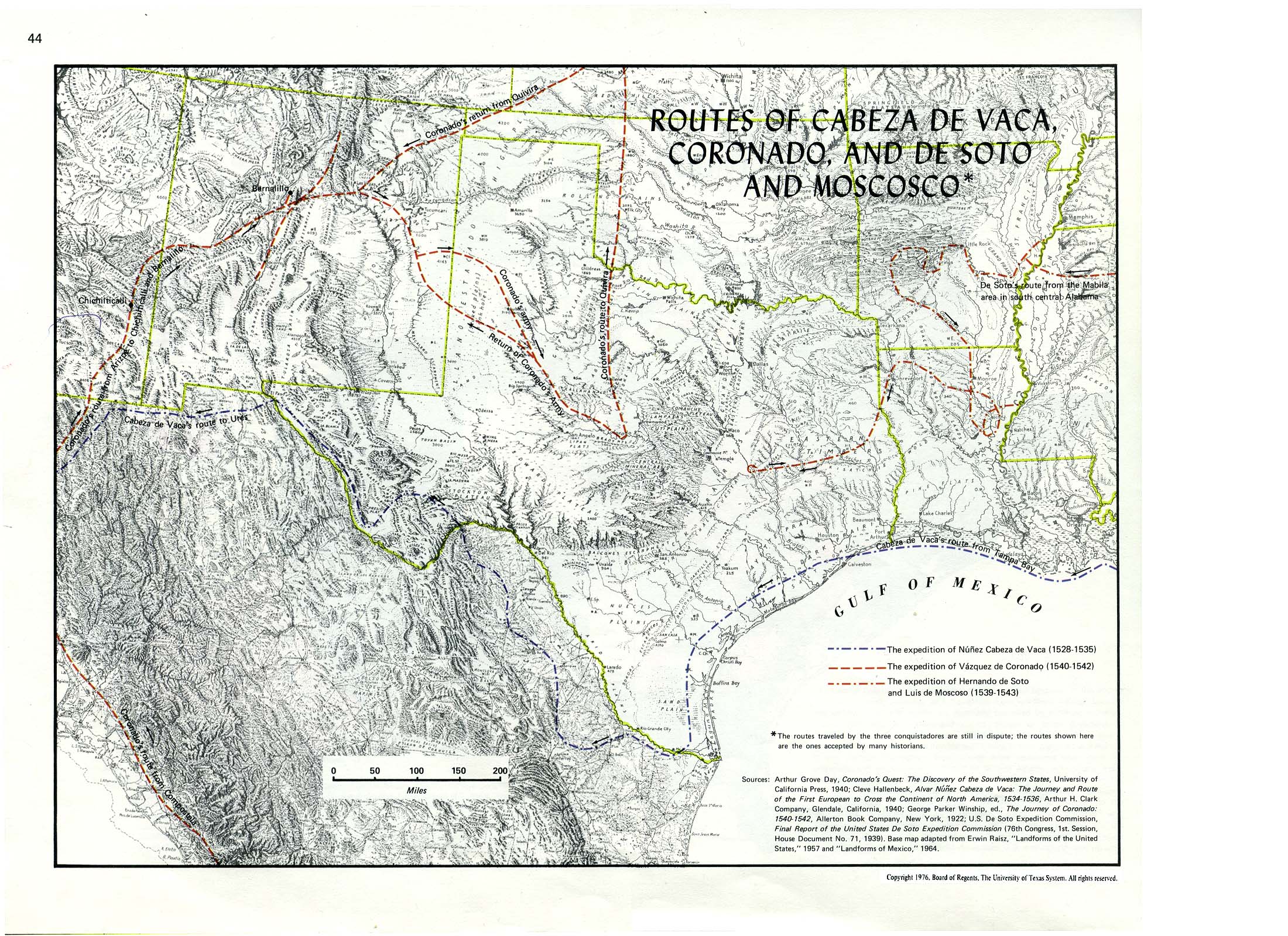
The current view from Texas:
http://www.lib.utexas.edu/maps/atlas_te ... lorers.jpg
Perhaps Parkins is a marginal site for the Desoto entrada, and it may simply reflect goods brought from Aminoya.
https://www.tshaonline.org/handbook/onl ... cles/uws01
Which leaves us to consider Porturgese map makers as well, friends of Joao De Castro, friend of Alonso de Santa Cruz.
Other DeSoto documents may perhaps be found there.
While the expedition wintered in Autiamque, they explored seven other new Provinces.
Most likely they were along the Arkansas River.
Perhaps Rangel recorded them in his diary.'
The Gentleman of Elvas made no mention of them - it is likely that he was on foot,
Perhaps they are recorded on the "DeSoto Map".
But you'd have to eliminate the other place names to isolate them.
(This will require determining the exact source for each place name on the map.)
The current view from Texas:
http://www.lib.utexas.edu/maps/atlas_te ... lorers.jpg
Perhaps Parkins is a marginal site for the Desoto entrada, and it may simply reflect goods brought from Aminoya.
Last edited by E.P. Grondine on Wed Apr 22, 2015 9:37 am, edited 1 time in total.
-
Frank Harrist
Re: The Search for Mabila, Winter 2014
I have studied and researched La Salle's disastrous attempt to find the mouth of the Mississippi River, but never knew the exact routes of these others. Thanks for the maps. This stuff is very interesting to me.
-
Kalopin
Re: The Search for Mabila, Winter 2014
Study the satellite view. See where the Tennessee river is at its lowest point in Alabama, where it widens? From this point follow the topography down to the southwest toward southeastern Mississippi.
Do you see the original river valley, that emptied out into the Gulf just at the southeastern Mississippi state line?
I believe, prior to the 1811 event, the Tennessee river was 'Y' shaped, was for the most part level to the west, flowed in either direction [as the Wolf river does today, depending on the water level], went straight to New Madrid Mo. [as seen on satellite view and also explains why New Madrid was positioned here],and this all changed after the meteor impact... [pushing the Tennessee river up to the Ohio river and pushing the Mississippi river to the northwest]
This may help, if you consider DeSoto probably followed the original river, up through Alabama close to where the Black Warrior river is, but before you get to Tuscaloosa... [it's possible the impact further buried the remains]
-
E.P. Grondine
Re: The Search for Mabila, Winter 2014
Look, Tony (Hood), there were plenty of people living in the area at the time.
What you claim to have happened did not happen.
The ramblings of nuts such as yourself, Steve Garcia, and Dennis Cox are not helping impact studies at all.
And your post here has no bearing on the topic at hand.
moderator?
What you claim to have happened did not happen.
The ramblings of nuts such as yourself, Steve Garcia, and Dennis Cox are not helping impact studies at all.
And your post here has no bearing on the topic at hand.
moderator?
-
Kalopin
Re: The Search for Mabila, Winter 2014
compare pre-1811 maps to post 1811... I have studied this many years...E.P. Grondine wrote:Look, Tony (Hood), there were plenty of people living in the area at the time.
What you claim to have happened did not happen.
The ramblings of nuts such as yourself, Steve Garcia, and Dennis Cox are not helping impact studies at all.
And your post here has no bearing on the topic at hand.
moderator?
Just go to my site, study the rocks, study the artifacts, a horseshoe and wagonwheel endcap fused with vitrified sand and impact melt rock. Understand there is no other mechanism to heat iron to the point of melt along with sand and rock and weld them together. How is this difficult? Yes, this is evidence to prove this scenario. Just because this is not understood does not mean it did not happen. Facts are facts, truth is the truth and can not be changed!
Chicxulub crater is no bigger than hundreds of impacts. It is current impact physics that is badly flawed...
If Mabila is near Tuscaloosa, then it is likely the 1811 meteor impact has relevance...
The evidence I describe is written down in the geography of this planet and can only be removed by another similar catastrophe. Why not? go study every single line?, every single detail?, Do you believe I am making up a satellite view?
-
E.P. Grondine
Re: The Search for Mabila, Winter 2014
Tony -
You do not know current impact physics.
Any more than you know history, geology, cartography, etc.
The topic here is Mabila and its location.
If you want to bring up your 1811 impact hypothesis again please do it with a separate post.
You do not know current impact physics.
Any more than you know history, geology, cartography, etc.
The topic here is Mabila and its location.
If you want to bring up your 1811 impact hypothesis again please do it with a separate post.
-
Kalopin
Re: The Search for Mabila, Winter 2014
o.k. you had enough time...E.P. Grondine wrote:Tony -
You do not know current impact physics.
Any more than you know history, geology, cartography, etc.
The topic here is Mabila and its location.
If you want to bring up your 1811 impact hypothesis again please do it with a separate post.
http://tolatsga.org/chick.html
the problem may lie in the fact that there is always more than one side to a story, but only one real truth?
see, turns out deSoto was not just a famous [jerk] conquistador, but quite the idiot. there was no 'battle' at Mabila, it was a massacre, women and children burned alive! de Soto was not an explorer and did not care at all about killing 'non Christians'. his mission was to find gold and treasure. when his men pulled necklaces Tascalusa told them to leave, starting the conflict...
the news traveled faster than de Soto, the Chickasaw were ready, burned one of the villages and abandoned another to make it look as though they had moved on, but this did not work. The Minko then had sqaws seduce de Soto and the Chickasaw made a surprise attack that night. This is when de Soto lost several men, horses, supplies and almost his life. after making it down the Mississippi river to Louisiana and convincing some of the natives there that he was 'an immortal sun god' he eventually died in Guachoya from wounds sustained in this battle [and not from a mosquito bite]
This is one of the main reason the Chickasaw were so feared, for what they had done to de Soto. this was the battle that ended his 'expedition' and it was 'just reward' for who he was and what he had done.
In 1809 the Chickasaw threatened open war, forced the U.S. calvary to remove more than five thousand squatters from the area before 1811 and, all of a sudden- ceded their land- 1832-1834... why? they did not fight in the 'war of 1812 [but for a very few who were punished badly for it]. They were willing to fight for their land before 1811 and then just gave it up afterward? ...and everyone was in fear of them... what happened?
de Soto has so many places named after him in this area to purposely spite the Chickasaw. he found no treasure because of who he was, but became famous for his 'expedition', exploits and 'finding' the Mississippi river [1541].
how does this version compare to what you have stated? How does my version compare to the first link you posted? which version sounds more authentic? Maybe go tell "A team of 17 academics- historians, archaeologists, folklorists and anthropologists, geographers and geologists-..."
...and let me know what they say- Was this [Mabila] the "bloodiest battle ever fought between Europeans and Native Americans" [Custer?]? Was the MASSACRE at Mabila the "...demise of the expedition and crippled Spanish dreams of colonizing the southeast"? Who doesn't know history? Who is teaching false beliefs?
you may want to study further? ;-]]]]]]]
...just so you'll hopefully look further into this-
the Chickasaw let them live, put de Soto's men in some boats and sent them down the river to tell everyone to stay the - off their land...[that's how he 'discovered' the Mississippi river!]
...thank de Soto for never seeing an 'Indian" girl adorned in gold and jewelry... yes, the natives had plenty gold, but since this incident anytime Europeans would come around it would be hidden... much of this was melted back into the earth- Dec. 16, 1811...and when the maps and satellite views are finally studied thoroughly this will be understood...
Do you really believe that that many Cherokee, Creek, Choctaw, Chickasaw warriors,... would just give away their lands?! after the 1811 event the land was considered 'cursed' , as they had lost so much and it had all changed... please give this all study and find the truth. Find out what happened to so many cities and such magnificent cultures lost in time... the defeat of these people was due to an extraterrestrial force- not from war or disease! correct this!
...for the great and unconquerable Chickasaw!
[-represent-beeoocchh- drop the mic!;-]
Last edited by Kalopin on Wed Mar 04, 2015 5:36 am, edited 1 time in total.
-
E.P. Grondine
Re: The Search for Mabila, Winter 2014
Kalopin -
Most of what you say about DeSoto is true,
but you need to check with the Chickasaw to get the details of their effort.
That still does not make what you say about an 1811 impact true.
My reason for doing this study is to recover Native American history, not out of any admiration for DeSoto or his soldiers.
-
E.P. Grondine
Re: The Search for Mabila, Winter 2014
The town of "Tani" at the lake was most likely the same town at the lake that the French later found the Tunica at.
(Correction: Taensas, see later post)
The map needs multi-spectral imaging.
Its drawing was interrupted mid-point. The first draft was following the Gentleman of Elvas's account. The final product uses Rangel's place names.
Note especially:
1) The duplicated places: Caya, Cayase, the duplicated lake at Autiamque.
2) The points with no names.
3) The unnamed towns
"mala" - was likely the burnt remains at Kincaid in southern Illinois.
"Aquigate" was Mound City, Illinois. I can not find a map or image of the remains that were there, before they were used to build the levee.
I don't care about "points". Send money.
Last edited by E.P. Grondine on Wed Apr 22, 2015 9:39 am, edited 2 times in total.
-
Frank Harrist
Re: The Search for Mabila, Winter 2014
Has anybody sent you any money yet, E.P? MY check is in the mail.
-
E.P. Grondine
Re: The Search for Mabila, Winter 2014
Hi Frank -
Yes, but its usually for books.
What I need to do is to set up a non-profit 501-3c for Native American and impact studies.
If Tim Cook wants to send me one of the new Mac laptops, that would help with putting things in e-book format.
So would an ipad to see if they are set up correctly.
Ed
Yes, but its usually for books.
What I need to do is to set up a non-profit 501-3c for Native American and impact studies.
If Tim Cook wants to send me one of the new Mac laptops, that would help with putting things in e-book format.
So would an ipad to see if they are set up correctly.
Ed
-
E.P. Grondine
Re: The Search for Mabila, Winter 2014
If "one" happens to go to the 1775 Purcell Smith map, and works their way up the Tombigbee River,
just south of Old Spanish Man there is Apfalaya, APFALAYA, just to the south of where the trail to Coosa (today's Montgomery) crosses the Tombigbee.
Lat year I located Guachoya (Yazoo, Vicksburg). This year Cayas (Caho/kia) and Apfalaya.
I recovered the first Rangel placde name from the 1544 map: "Tani", the Lake of the Tunica.
Also, the existence of a Totonac trading outpost which Cabeza de Vaca visited, and which started the conquistadors on their way, on the Texas Gulf has been demonstrated.
(CORRECTION:
Also, the existence of a HAUSTECAN trading outpost which Cabeza de Vaca visited, and which started the conquistadors on their way, on the Texas Gulf has been demonstrated.)
This site must be close to UT Austin, and locating it further should provide them with a nice project.
Since the geological source of Meso-American turquoise is known,
the effort of locating this trading post should be straight forward.
(But the area has been subjected to massive hurricanes.)
Just look for their pottery.
Or better yet, survey the coast using metal detectors.
its going to be difficult to go through all the Cabeza deVaca sources to try and place this account in them.
as the information was tightly held at the time.
As far as the location of the Battle of Mabila goes, the question now is where "Tali" was on the Tombigbee River.
My current estimate is that it was the particular "Tali" that was a part of the Hattak Hunnali Hosh,
today's (and the colonists') St. Stephens.
Mabila was either in the area of Montgomery or Burnt Corn, and on the native trails ("public highways"), which the Spanish Entrada was using.
Last edited by E.P. Grondine on Wed Apr 22, 2015 9:46 am, edited 3 times in total.
-
E.P. Grondine
Re: The Search for Mabila, Winter 2014
A note on travel distances:
If one looks at the records of General Clark's attacks during the revolutionary war:
his company's travels from Louisville (Clarksville) to Vincennes and Kaskaskia, they' give you fast travel times for Europeans using Native trails.
For DeSoto my working estimate is currently about 40 miles per day by horse, in other words 20 mIles out and back,
and about 20 miles per day by foot.
Tenderfoot Boyscouts can do 10 miles per day.
These guys were Spanish soldiers thirsting for gold.
Last edited by E.P. Grondine on Mon Mar 09, 2015 10:22 am, edited 1 time in total.
-
E.P. Grondine
Re: The Search for Mabila, Winter 2014
While the Spanish records have been pretty well gone through, though gaps still exist in the understanding of the court intrigues,
Portuguese records have still not been worked through.
That is because Portuguese is a much more difficult language than Spanish, and the finding tools are far less well developed.
Aside from that, it is because too many well paid North American archaeologists are PFs, who have no idea what a really good apparat for anthropological work consists of.
QED