Page 2 of 5
Posted: Fri Apr 11, 2008 9:42 pm
by dannan14
john wrote:
All -
That the Australians could voyage there means that they could also voyage back.
Think about it.
hoka hey
john
Why wouldn't the people who stayed on the mainland be the ones to expand on the mainland?
Posted: Mon Apr 14, 2008 5:33 pm
by Rokcet Scientist
john wrote:That the Australians could voyage there means that they could also voyage back.
That is on the as yet unproven premise that 'voyage' was by watercraft.
If, OTOH, that 'voyage' was really a hike, a trek, following coastlines (their food source) overland(bridges), then at
some time after their arrival a 100 mile gap/sea strait – with extremely strong and trecherous currents and tidal forces! – came to be. Uncrossable with the knowledge and technology of the day. And since. Until Europeans reintroduced it 400 years ago.
In
that scenario – equally unproven, so equally valid until disproven – the interesting question would be:
when did the sea strait come to be that isolated Oz' conquerors from whence they came?
(And the
how could be an amazing story too! Material for a prequel to the movie "10,000 BC" – "40,000 BC" – even, with impressive special effects and liberal application of CGI).
Most interesting: that scenario happened
twice to the same people! At the beginning of the holocene the people on the
then Tasmanian
peninsula got isolated from mainland Oz by rapidly rising sea levels. As far as we know they lost all contact since.
Any geologists in da house?
Posted: Mon Apr 14, 2008 7:05 pm
by Beagle
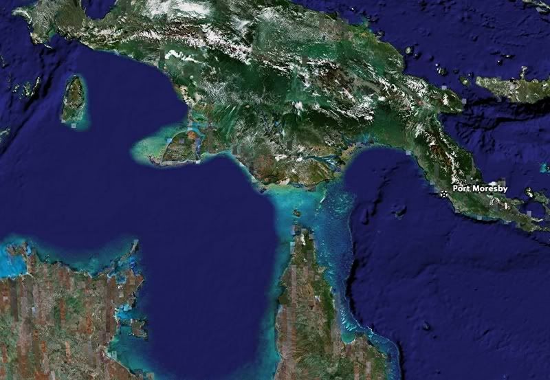
RS, you old booger, I thought we did this. The continent you're referring to was called Sahul. It's the combination of Australia, New Guinea, and Tasmania. The Sahul was always separate from the larger continent of Sunda, which is all of Indonesia above water. The water between them was called the Sahul Strait.
http://archaeology.about.com/od/sterms/g/sahul.htm
Sahul is the name given to the single Pleistocene-era continent which combined Australia with New Guinea and Tasmania. At the time, the sea level was as much as 150 meters lower than it is today; and it was separated from the other great land mass (Sunda) by the Sahul Strait. The island in the photograph would have been part of Sahul.
Archaeologists care about this ancient continental shift because to get the Sahul populated, people had to actively work at getting there from the Sunda (in other words, they had to have boats or rafts and were likely to intend getting there). Currently, there are two theories about when this happened: 60,000 or 40,000 years ago. Scholars do agree that there are sites in Australia that date to at least 40,000 years ago, including Devil's Lair, Lake Mungo, Nauwalabila, and Malakunanja. The O'Connell and Allen paper listed below is an excellent review of the recent considerations.
But I don't think you're ever going to be convinced. That's ok.

Posted: Tue Apr 15, 2008 1:41 am
by Rokcet Scientist
Beagle wrote:But I don't think you're ever going to be convinced.
Sure I will. By PROOF.
Until then one premise is as good as another.
Posted: Tue Apr 15, 2008 2:23 am
by Digit
No RS you don't want proof! You want support for a hobby horse.
Forget Oz and answer the question I've thrown at you time and again and that you have ignored.
The Andaman Islands have apparently been occupied since before you claim that seaworthy craft were developed. Do you have a land bridge for those?
Posted: Tue Apr 15, 2008 9:01 am
by Rokcet Scientist
Digit wrote:No RS you don't want proof! You want support for a hobby horse.
Forget Oz and answer the question I've thrown at you time and again and that you have ignored.
The Andaman Islands have apparently been occupied since before you claim that seaworthy craft were developed. Do you have a land bridge for those?
No.
That doesn't mean there wasn't one. In fact we are talking about that part of the Earth's crust that is by far the most tectonically/volcanologically active on the globe. The Earth's crust has risen and fallen a helluvalot in that region for hundreds of millions of years. Illustration: the Toba eruption – the most violent that we know of that ever happened – actually happened almost round the corner from the Andamans on Sumatra!
(And the abo's may have witnessed it on their trek to Oz. 74,000 years ago is roughly about the same time they possibly 'passed through' Sumatra. Maybe it's even in one of their myths).
Or, for your convenience a bit more recent: the 2004 tsunami (which almost destroyed the Andamans!).

From Wikipedia:
The volcanoes in Indonesia are among the most active of the Pacific Ring of Fire. They are formed due to subduction zones between the Eurasian Plate and the Indo-Australian Plate. Some of the volcanoes are notable for their eruptions, for instance, Krakatau for its global effects in 1883, Lake Toba for its supervolcanic eruption estimated to have occurred 74,000 BP which was responsible for six years of volcanic winter, and Mount Tambora for the most violent eruption in recorded history in 1815.
Posted: Tue Apr 15, 2008 9:14 am
by Digit
That doesn't mean there wasn't one.
So now I've got to imagine, not one land bridge, but two?

And the Andaman Islands an area of tectonic activity?
The Malay archipelago is so active because it is under pressure from the Australasian land mass moving north.
The Sunda straight is now narrower than it has been in the past, shallower than it has been in the past and locically has a stronger current that it had in the past.
And you still dodge the fact that your imaginary land bridge seems only to have popped up long enough for man to scamper across but no large animals, perhaps they didn't have boats to help them?
Almost destroyed the Andamans? Since when?
Posted: Tue Apr 15, 2008 9:36 am
by Rokcet Scientist
Digit wrote:
So now I've got to imagine, not one land bridge, but two?
No.
Hundreds!
Try the Bering landbridge. Or are you contesting that one too? Or the Dardanelles. Or the Pillars of Hercules. Or the landbridge(s) connecting Caribean Antilles with the South American mainland.
And, and, and.
Landbridges – appearing and disappearing – are a staple feature/occurrence in geology.
Almost destroyed the Andamans? Since when?
Since Boxing Day, 2004...
(Or did you miss that date?)
But apparently the news never got through to you. Not surprising. Thailand, Sumatra, and Sri Lanka stole all the 'limelight' then as the 'heavily hit areas'. The Andamans were simply completely neglected, ignored, in the news reporting.
As you demonstrate.
Posted: Tue Apr 15, 2008 10:19 am
by Digit
I mistook your English RS, when you said 'destroyed' I assumed that you meant they were destroyed, ie physically removed from the face of the Earth, as with your imagined land bridge, in which case you are incorrect.
I have no doubts about the straits you mention, but their existance is hardly 'proof' of the existance of the the others I am supposed to accept. Just because the Bering strait existed to assume one to the Andamans must have is very poor reasoning indeed.
This article will probably not influence you one iota but it does mention that the Andamans acheived their present configuration 26000000 years ago, a litlle early for your perambulating humans I feel.
http://forest.and.nic.in/frst-island1.htm
Andaman Islands
Posted: Tue Apr 15, 2008 10:24 am
by Cognito
Alright you two, settle down and read through this:
http://www.andaman.org/BOOK/chapter24/text24.htm
The Andaman Islands would have been
very close to the mainland during the Pleistocene LGM when the seas were 120 to 140 meters below current level (see maps). However, I doubt they were connected and it would still require some sort of boat or raft.
Of course, New Guinea and Australia were connected at that time, making for one BIG-ASS continent. BTW, keep me out of the argument since I promised my daughter I would be a kinder-gentler person today.

Posted: Tue Apr 15, 2008 10:57 am
by Rokcet Scientist
Digit wrote:I mistook your English RS, when you said 'destroyed' I assumed that you meant they were destroyed, ie physically removed from the face of the Earth
It seems my English is better than your reading of it, Dig... Read it again. I said 'ALMOST destroyed' them!
The Andamans are still there. But were whacked very badly.
Posted: Tue Apr 15, 2008 11:40 am
by Digit
It wasn't the 'almost' I was querying it was the 'destroyed'. How do you 'almost destroy' something? If you meant badly damaged, say so.
They were indeed Cog, but according to my research the channels were never less than 400mtrs deep during the likely period for a migration, so as you say, some form of water craft would have been required.
Posted: Tue Apr 15, 2008 11:48 am
by Rokcet Scientist
Digit wrote:It wasn't the 'almost' I was querying it was the 'destroyed'. How do you 'almost destroy' something?
If you don't know that, Dig, then sadly it is going to take too long to explain in text.
If you meant badly damaged, say so.
FYI: 'almost destroyed' = 'badly damaged'.
You must've slept very badly.
Posted: Tue Apr 15, 2008 11:49 am
by Beagle
Rokcet Scientist wrote:Beagle wrote:But I don't think you're ever going to be convinced.
Sure I will. By PROOF.
Until then one premise is as good as another.
Howdy RS. That's cool, but a boat or a raft carbon dated to 40,000 BC is never going to be found. So, I'm curious...will anything constitute proof?
Posted: Tue Apr 15, 2008 11:57 am
by Rokcet Scientist
Beagle wrote:Rokcet Scientist wrote:Beagle wrote:But I don't think you're ever going to be convinced.
Sure I will. By PROOF.
Until then one premise is as good as another.
Howdy RS. That's cool, but a boat or a raft carbon dated to 40,000 BC is never going to be found. So, I'm curious...will anything constitute proof?
I sure hope so. Obviously I don't know what form that proof will take. You seem already convinced it won't be a boat. But why not? How about good old fossils? Of boats, this time. Their – carbon – structures, like – carbon – skeletons, might have left imprints in calcium or sandstone formations. The Valsequillo footprints are dated how old again...?
Maybe we will find a perfectly preserved boat in the 6 meters (20 feet) of volcanic ash that the Toba eruption deposited (wouldn't that be nice for dating puposes!).
We found Pompeji and Herculaneum perfectly preserved, didn't we?