The Yeti, Sasquatch, and Nessie photos are a lot clearer....Beagle wrote:
This one has a picture.
Marine Archaeology
Moderators: MichelleH, Minimalist, JPeters
-
Rokcet Scientist
-
Rokcet Scientist
Let's invite this guy to the board!
Times article: http://www.timesonline.co.uk/tol/news/u ... 873026.ece
Wreck of Australian Warship HMAS Sydney Found?
Tim Ankers, a British archaeologist, claims to have found the wreck of the HMAS Sydney, lost with all hands in the Indian Ocean during World War II. He says that he's done this from the comfort of his home using software he wrote called Merlindown, which can analyze satellite photographs at different wavelengths to 'peer 75 meters into the earth and 16,000 meters beneath the seas.
Times article: http://www.timesonline.co.uk/tol/news/u ... 873026.ece
-
Forum Monk
- Posts: 1999
- Joined: Wed Dec 27, 2006 5:37 pm
- Location: USA
Yes. Yes. Very interesting article. Very good.
I find it very interesting because software analysis of satellite data is very cool for me and this has amazing potential for archaeological research if this proves valid.
When I first saw the post though, my first thought was how did he obtain the satellite images as they are not routinely available; especially in multiple wavelengths and many commercial satellites operate only in the optical range. I see he 'bought' the images. I suppose finding a few wrecks could afford him lots of images.
http://ishk.com/civilization_early_years.pdf
Civilization: The Early Years.
An 8 page PDF. I found it interesting and thought provoking. An easy read.
Marine archaeology seems to be on the verge of a new Age of Discovery.
Civilization: The Early Years.
An 8 page PDF. I found it interesting and thought provoking. An easy read.
Marine archaeology seems to be on the verge of a new Age of Discovery.
-
Rokcet Scientist
-
Rokcet Scientist
I see.kbs2244 wrote: I was thinking more of a "historical" timeframe.
Or, at the least, human existence, timeframe.
That is the allure of continental shelf under water archeology.
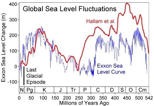
Is this what you mean?
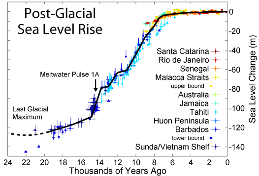
or this?

One very convenient aspect of marine archaeology is the depth-is-age angle. The depth of the find, below average sea level, calibrated, could turn out to be a pretty good indicator of its age. A welcome extra tool in the marine archaeologist's dating arsenal.
When is somebody going to build a sea level simulation? A zoomable world map that shows the coastlines at the point in history that you specify. With GPS coordinates of course.
Looks like something for the WWW to me. A collaboration with Google Earth seems in order.
Interesting times ahead.

-
Rokcet Scientist
It could be extended into a "coastlines of the future" projection too. Could be convenient in the global warming debate...kbs2244 wrote: I never thought of the depth as an age indecator. But it makes all kinds of sense.
I have neither the time nor expertise for your "coastlines of the past" idea, but I will be in line to buy it if someone does it.
-
Forum Monk
- Posts: 1999
- Joined: Wed Dec 27, 2006 5:37 pm
- Location: USA
Hmmm. I have the data and have already written a dumbed-down version for personal use except I pick a sea level and it builds the map, not a date. I thought to build a more elaborate version for distribution but I lack time and motivation as I am very busy at work these days and when I get home I have things to do outside. We're having a really decent summer and I want to take advantage of it.Rokcet Scientist wrote:When is somebody going to build a sea level simulation? A zoomable world map that shows the coastlines at the point in history that you specify. With GPS coordinates of course.
-
Minimalist
- Forum Moderator
- Posts: 16046
- Joined: Mon Sep 26, 2005 1:09 pm
- Location: Arizona
But that gets it out of the realm of fact and into the realm of fiction.
I would rather it stay within the realm of your graphs.
I have never double checked them, but assume they are creditable.
A Goggle Earth version, that only allowed negative dates, would just make that same data easier to grasp for a given location. And give a greater number of people access to, and a comprehension of, that kind of data.
The guys in India are talking about finding submerged ports at their river deltas.
This would help us in finding places to look at how many river outlets?
The Amazon, the Niger, the Yellow, the Mekong, the Hudson, the Rio Grande, the Rhine, the list is never ending.
I will admit to being a believer in early long distance ocean travel. But the problem has always been finding the ports. Rivers have long been the highways inside the continents and their mouths the transition points to the open water sailors.
If it were easy to visualize the different water levels at a given point in time, then things that do not seem reasonable now may start to make sense.
The next step would be to bring it to inland water levels. I live in the Chicago area. The river I grew up next to, the Des Plaines, is less than 5 miles from Lake Michigan, but the water goes into the Illinois River to the Mississippi River to the ocean. There is a town in central Wisconsin called Portage because it is where the French, following Indian trade routes, would portage from a river that flows into Lake Michigan into one the flows into the Mississippi. If Lake Michigan was 30 feet higher you could paddle, without portage, all the way from Canada to New Orleans on either river. Or, of course, you could go East, portage around Nigeria Falls, and head down the St Lawrence also. The St Clair, at Detroit, would just be a narrow, but calm, spot.
What would the trade consequences be in such a case? What kind of stuff and ideas would go down stream and back upstream in such a case?
What if we were talking about the Indus, or the Amazon, or the Niger, or the Yellow, instead of the Mississippi?
I guess the point I am trying to make is that when we stand at the waters edge, we tend to think that “this is where it begins”, or “ends“. It is an emotional dividing line that has “always been there.” When in fact, it hasn’t always been right “here” from a GPS point of view.
When can I buy it? And what can I do to make it a best seller?
I will get off the soap bow now.
Thanks.