There is no single Nile river level, kb. It's a river flowing south-north, so, like Digit said, the level in the south is higher than in the north.kbs2244 wrote:If the current Red Sea level is higher than the Nile River level
Red Sea to the Nile
Moderators: MichelleH, Minimalist, JPeters
-
Rokcet Scientist
Re: Red Sea to the Nile

Re: Red Sea to the Nile
I've given a lot of thought to these various problems kb, some comments are based on physics, some on good engineering, some on logic and some frankly, guesses, but I see the whole thing thus.
First let us wind the clock back, how far I know not, but there was a time before the delta when the Nile would have have had a 'normal' estuary. The silt coming down river would have formed an area of mud flats that would have advanced into the Med. Eventually a stasis would have been reached where tidal/wave action halted the advance, thisis all perfectly conventional.
As the flats advanced the river's length increases, this reduces the river's gradient and results in silt being dropped further upstream, this can result in the river breaking out of its banks. This then spreads the silt into the familar 'flood plain'.
In the case of the Nile this has been repeated for many years so that the mud flats have risen well above local sea level and created the Lotus shaped delta.
Any route that the Nile took in the past has almost certainly changed many times as the land continued to rise.
A map of the delta ascribed to Herodotus does not show the modern Wadi Tumilat. Now Min suggested that this represents an ancient water course, and there is good reason to agree, but which way did the water flow?
The answer could well be 'both ways', at different times.
Before the delta reached its present height there could well have been a flow from the Red Sea into the Nile, but then as the Nile backed up the current could well have reversed! There are also suggestions that the Red Sea is retreating south due to the land rising.
The current delta is being washed away by the Med due to the second Aswan dam, as was predicted, this erosion will continue till the dam is breached and the Nile inundation restored or some protection in the way of sea defences intalled. If the erosion continues salt water will encroach further up the Nile destroying farm land as it does so.
Egypt faces an uncertain future if they coninue to ignore the obvious.
Roy.
First people deny a thing, then they belittle it, then they say it was known all along! Von Humboldt
-
Minimalist
- Forum Moderator
- Posts: 16046
- Joined: Mon Sep 26, 2005 1:09 pm
- Location: Arizona
Re: Red Sea to the Nile
Egypt faces an uncertain future if they coninue to ignore the obvious.
Insh'allah.
(Ever the problem with religion.)
Something is wrong here. War, disease, death, destruction, hunger, filth, poverty, torture, crime, corruption, and the Ice Capades. Something is definitely wrong. This is not good work. If this is the best God can do, I am not impressed.
-- George Carlin
-- George Carlin
Re: Red Sea to the Nile
To be honest Min the 'engineering' solution is to build the required number of nuclear power stations then blow the bloody dam up. God alone know how much silt there now is in Lake Nasser, all dams on such rivers have to be 'bled' regularly to prevent choking of the turbines, but I'm not convinced that has much effect away from the dam.
The weight pressing down on the valley floor can only be sustained for a certain depth/time. All dams are 'relatively' short on life.
On top of their other problems the lake now causes medical problems, such as TB, 'cos the atmospheric moisture has raised the humidity beyond what the people have been used to for generations.
Some people never learn, AKA 'The Three Gorges Dams!'
Roy.
First people deny a thing, then they belittle it, then they say it was known all along! Von Humboldt
Re: Red Sea to the Nile
It would seem there is very small, if any, tidal action in either the Med or the Red Sea.
http://curious.astro.cornell.edu/questi ... number=627
Page 6 of
http://www.gloss-sealevel.org/publicati ... r_2004.pdf
http://mapsof.net/Suez_Canal
Lake Timsah appears to be a wide spot in the current canal.
It would thus be salt.
The small lagoon to the west side of the canal road is connected under a bridge.
So it would also be salt.
But if you look farther west you can see what is unmistakable irrigated land along what would seem to be the what is left of the old delta branch.
That reminder seems to bend south into an irrigation canal that starts by the airport and is actually dammed off from entering the current navigation canal at the east end.
http://en.wikipedia.org/wiki/Lake_Timsah
This seems to say that Nile River fresh water flowed into the current canal until the Aswan dam. Then the dam lowered the river level to the point where the flow would be slowed or even reversed so that, at the least, the lake became brackish.
So, I am guessing, pending an on site visit, that we are talking about fresh vs. salt water levels in that area that may be measured in inches.
The protection of the farm lands from salt intrusion would lead to dikes and dams to keep the post dam salt water from the current canal from spreading west.
And the now relativity low river levels would keep any flow in the old branch to very low if any.
The old navigation canal has been reduced to an irrigation water supply.
Re: Red Sea to the Nile
Most of that is spot on kb. But I would take issue on the name of the bitter lakes being based on their being salt water in the sense of sea water.
That may well be absolutely correct, I don't know.
I have been unable to discover when, and by whom, they were so named.
If those who chose that name were not familiar with salt water then that name would be appropriate, if they were familiar with salt water then they obviously meant something else!
On your points about the area of cultivation. Therein, I suspect, is the solution to much of this debate. If the lakes are lower than their feeders then salt, whether from the Nile waters or the Red Sea, would become increasingly concentrated due to evaporation, ie, the Dead Sea.
This fortunate circumstance would then keep the fresh Nile waters from salt contamination by waters from the Rea Sea.
Did the builders understand that, did they just get lucky?
If they knew then we have to credit them with considerably more than we do.
Tidal variations kb have to be considered within their phase relationships. The tides on opposite sides of Panama are some hours apart, so that the max diff between them is as much as 20ft, so even if the canal had not been locked for other reasons this alone would have required some form of gate/lock.
Keeping salt water out of the delta might well be accomplished with dykes etc, but that is only a part of Egypt's problem. The flood provided not only water for irrigation but fertiliser in the form of silt, now Egypt spends a fortune on fertilisers to compensate!
In addition they are/will face the same problem that we faced over the years in East Angila, loss of soil during harvesting. The end game then requires the dykes to move further up stream.
Also even that may not solve the problem. You may well prevent water from flooding the land with dykes but that may not prevent salt water leaching underneath and poisoning the land that way.
What grieves me is that all this was, and is well known, and still the rulers proceed.
As yesterday's mistake was so sucessfull we will be repeating it again in the future!
Roy.
First people deny a thing, then they belittle it, then they say it was known all along! Von Humboldt
-
Minimalist
- Forum Moderator
- Posts: 16046
- Joined: Mon Sep 26, 2005 1:09 pm
- Location: Arizona
Re: Red Sea to the Nile
Always go to the maps.
http://www.lib.utexas.edu/maps/ams/afri ... 9th-ed.jpg
This one is zoomable. Click on northern Egypt west of the Suez canal for a close up of the region under consideration.
One, the region in question is classified as "sand" according to the legend at the bottom. Two, the Suez Canal ends at Ismailia and ships continue through the same Bitter Lakes which, thus, must be deep enough for large ocean-going vessels. One assumes it was equally deep in antiquity although no one would have cared.
But it is "three" which is even more interesting. The map also shows the modern Ismailia Canal heading from the Nile to Ismailia.
A search for that revealed.
http://www.planetware.com/ismailia/isma ... m-ismc.htm
http://www.lib.utexas.edu/maps/ams/afri ... 9th-ed.jpg
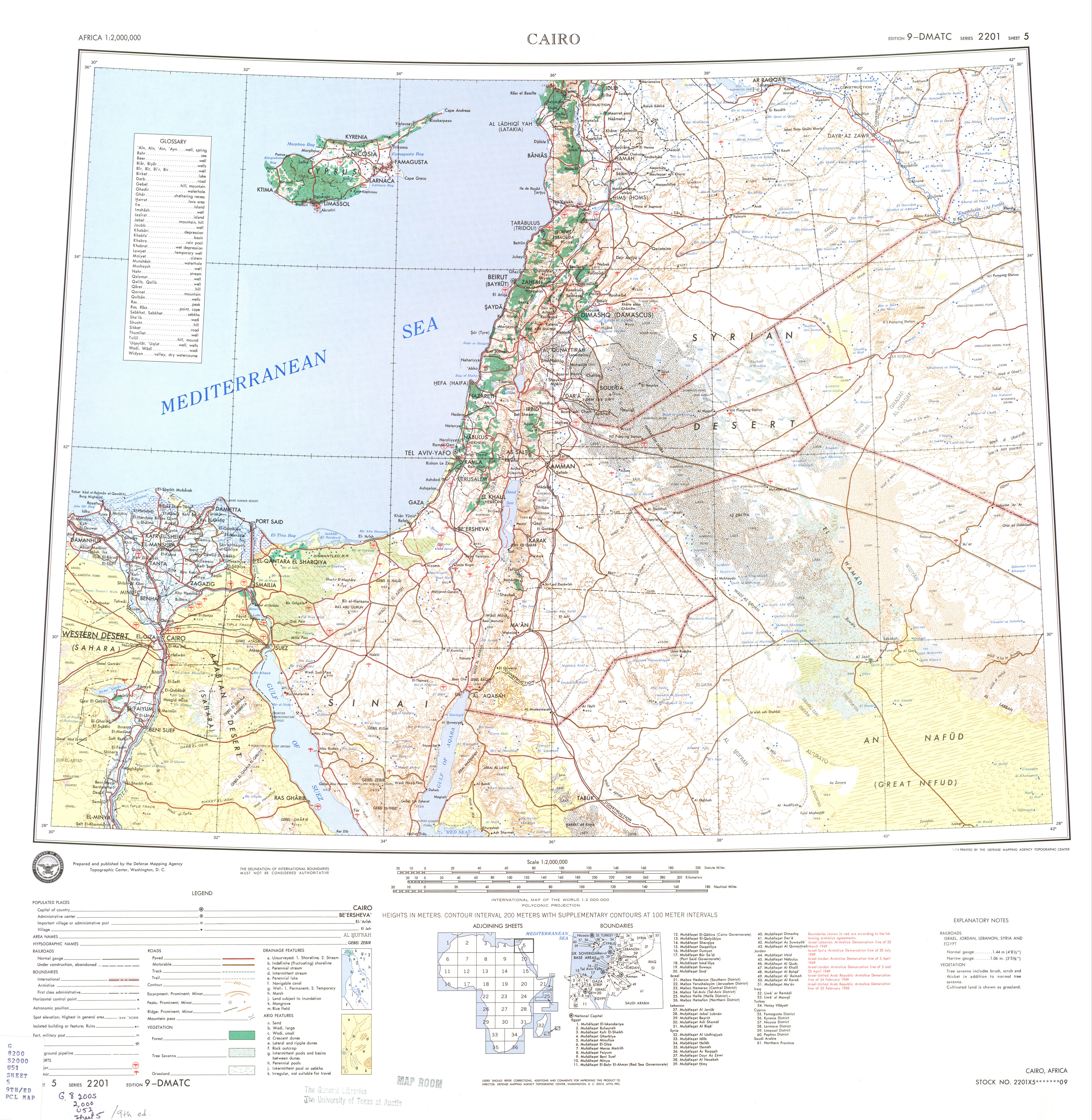
This one is zoomable. Click on northern Egypt west of the Suez canal for a close up of the region under consideration.
One, the region in question is classified as "sand" according to the legend at the bottom. Two, the Suez Canal ends at Ismailia and ships continue through the same Bitter Lakes which, thus, must be deep enough for large ocean-going vessels. One assumes it was equally deep in antiquity although no one would have cared.
But it is "three" which is even more interesting. The map also shows the modern Ismailia Canal heading from the Nile to Ismailia.
A search for that revealed.
http://www.planetware.com/ismailia/isma ... m-ismc.htm
Bold added.The Ismailia Canal or Freshwater Canal, constructed in 1858-63 to supply the villages on the Suez Canal with drinking water and enlarged in 1876, is to a large extent a modern replacement of an ancient canal dating from the Middle Kingdom which ran east from the Nile, watered the Biblical land of Goshen with its various branches and flowed into the Bitter Lakes, making them sweet (as Strabo tells us) and connecting them with the Red Sea.
Something is wrong here. War, disease, death, destruction, hunger, filth, poverty, torture, crime, corruption, and the Ice Capades. Something is definitely wrong. This is not good work. If this is the best God can do, I am not impressed.
-- George Carlin
-- George Carlin
Re: Red Sea to the Nile
I agree with your concerns about the long term effects of major dams Digit.
We have the same problem in the States in what is called the Imperial Valley is southeast California.
For decades it has be irrigated by the waters in the Colorado River that are left over form what is diverted for Las Vegas, LA, and Phoenix.
The soil salts have leached upwards to the point that more water is needed to flush them than is needed for the plants.
If you Google Earth it you can see the US/Mexico border clearly due to water use.
Where the Colorado enters the Gulf of California you can wade it without getting your knees wet.
And this a truly major river!
But this has been fun.
I think we all can agree there was shipping between the Red Sea and the Med on an off and on basis throughout history.
And that is what I was trying to discover.
-
Rokcet Scientist
Re: Red Sea to the Nile
That sufficient depth "for large ocean-going vessels" in the Bitter Lakes is the result of the permanent dredging of an underwater canal (thus invisible), a.k.a. a trench. Exactly like in the lakes that the Panama Canal goes through. Without permanent dredging no "large ocean-going vessels" can get through. Where they are not dredged (95%) the Bitter Lakes are very shallow. As in knee-deep to waist-deep – 2 to 4 feet. No deeper.Minimalist wrote:ships continue through the same Bitter Lakes which, thus, must be deep enough for large ocean-going vessels.
...wadeable...
So for human passage the water was not an insurmountable obstacle.
Now, the reeds... that's a whole different story. Huge plains of half submerged sharp edged reeds are still today a big PITA for any vehicle. Let alone when you're trying to cross them, and the sucking peat they grow in, barefoot or sandalled!
No, they didn't have dredging equipment/technology. So, if anything, it must have been equally shallow in antiquity. But possibly deep enough for the boats of the era. Primarily in-land boats, I would think, but possibly even open sea boats, depending on their building style. Viking ships, for instance, drew no deeper than 2 feet, and used articulated long, big outboard blades, 'swords', to counteract drift and roll when there was sufficient depth to use them like at sea.One assumes it was equally deep in antiquity although no one would have cared.
So Viking ships could have sailed the Bitter Lakes.
Which of course begs the question: "Did they?" Did Vikings travel roughly the route of the Suez canal, carrying their boat if they had to, but floating most of the way, to the Red Sea? And beyond? To India perhaps? Or even China?
But I digress. Again.