Fortuneteller wrote:1. On page 150 of his book, Mr. Osmangich describes profile of the well B-1 and points out: "At a depth of depth 3.7m, clay changes into marlstone, which is geologically impossible, because of a very short period ("it cannot happen in 20,000 years").
This is completely untrue. All the change from clay to marl indicates is that environmental conditions changed in the Miocene lake while these sediments were accumulating. In fact, if Mr. Osmangich and the geologists working for him would research was has been pubished on the geology of the Visoko region, they would find out that the interlayering of marlstone, clay, sandstone, conglomerate, breccia, and coal is typical of the 2.5 to 3.0 kilometer thick sequence of sediments, which locally underlie the area around Viocica Hill.
Fortuneteller wrote:Geologist Nadja Nukic in her report had not recorded this data as anomalies. On profile B-1 at a depth of 3.7m clay changes into clay marlstone, which is entirely natural.
An excerpt of the Sarajevo Sheet of the 1:500000 scale Geological Map of SFR Yugoslavia published in 1970 by the Federal Geological Institute in Belgrade, with Visoko is in the right hand corner, can be found at:
http://www.sediment.uni-goettingen.de/t ... sch-02.jpg
In this excerpt, Oligocene to Miocene lake deposits, which accumulated in an intramountain basin sometime between 5.3 to 23 million years ago, are labeled "OlM", "M1,2"; "M2"; "M2,3"; and "M3". The suffixe "M" = Miocene and "Ol" = Oligocene. The prefixes indicate oldest to youngest strata starting with 1 = Lower; 2 = Middle; and 3 = Upper. The two geologic units comprising the Bosnian "pyramids" are "M2,3" and "M2". According to the available published literature and other geologists, whom I have consulted, Unit "M2,3", which comprises almost all of Viocica Hill, consists of Middle to Upper Miocene "Lasva conglomerate", which contains an interlayered mixture of conglomerate, sandstone, and marlstone along with some clay and coal. As indicated by the ovals in the pattern for this unit, it contains a significant amount of conglomerate. The pebbles, found within these conglomerates, consist of limestone, sandstone, other sedimentary rocks and various igneous and metamorphic rocks derived from the adjacent mountains. Unit "M2" consists of Middle Miocene marl, sandstone, and clay along with soem coal. The mountains flanking the valley in which Visoko lies consists of highly faulted, folded, and otherwise mangled Mesozoic and Paleozoic sedimentary, igneous, and metamorphic rocks.
According to its legend, some of the other symbols on the above geologic map are:
"A" = Amphibolites
"C" = Undifferentiated Carboniferous strata.
"J2,3" = Dogger: Jurassic limestone with hornfels.
"J,K" = undifferentiated Cretaceous and Jurassic mixed limestones and sandstones.
"K2" = Cretaceous sedimentary rocks.
"P3" = Upper Permian sandstones and sericite-Chlorite schists.
"P,T" = Permian and Triassic sandstones, limestones, and quartzites.
"Pz" = Undifferentiated Paleozoic strata.
"Q1" = Undifferentiated Pleistocene deposits.
"Q2" = undifferentiated holoecen deposits.
"S,D" = Silurian and Devonian mixed limestones, sandstones, and shales.
"T1" = Lower Triassic mixed limestones and sandstones.
"T2" = Undiefferentiated Middle Triassic strata.
"T2,3" = Middle to Upper Triassic mixed limestones, dolomites, and sandstones.
beta,betaJ = Jurassic diabases and spyllites
omega = ultramafic rocks (ophilites, ancient ocean crust)
"xPz2" = Ryholites and quartz porphyrites
Some publications concerning the geology of the Visoko region and the Miocene lake deposits comprising it and the landscape around it.
Cicic, S., and Milojevic, R., 1970, Terestricko-limnicke
naslage neogena u Bosni i Hercegovini {Terrestrial-limnic
facies in Bosnia and Herzegovina]. Geoloshki Glasnik
[Bulletin Geologique] (Sarajevo). no. 14, pp. 19-32.
Laubscher, H. P., 1983, The late Alpine (Periadriatic)
intrusions and the Insubric Line. Memorie della Societa
Geologica Italiana. vol. 26, no. 1, pp. 21-30
Tari, Vlasta, and Pamic, J. 1998, Geodynamic evolution
of the northern Dinarides and the southern part of the
Pannonian Basin. Tectonophysics. vol. 297, no. 1-4,
pp. 269-281
Fortuneteller wrote:2. On page 159 Mr. Osmanagich wrote: "At a depth of 4.7m (B-1), a "brown stone", which would become the main mystery of these probings, is found for the first time.
Geologist Nadja Nukic did not see that as an anomaly. On the profile of the well B-1 at 4.50-5.85m, she noticed clay iron carbonate sandstone.
3. On page 151, Mr. Osmanagich explained: "There is a very important anomaly at 7.80m: marlstone, gravel and traces of black (organic material)"
Geologist Nukic commented that there are "clay, marlstone, and coal with gravel and sand", but she emphasized that some material falling from the walls of the well could occur.
As noted above there is nothing anomalous about any of these above findings as Viocica Hill and the hills around it are underlain by Middle to Upper Miocene conglomerates, clays. sandstones, marls, and coal. Anywhere a person drills in the local area of Viocica Hill, they will find "brown stone", "clayey iron carbonate sandstones", marlstone, coals, conglomerates, gravel, and sand interbedded with each other and other sedimentary rocks. A quick look at what has been published in the geological literature and the 10:000 scale geologic map, which covers this area, would quickly reveal there is nothing anomalous about what Mr. Osmanagich or Nadja Nukic found in the drill holes.
Fortuneteller wrote:4. On page 153, Mr. Osmanagich wrote: "at a depth of 9.90 to 10.20m (B-1) there is a layer of "decorative stone" with traces of iron (?)"
This has not been considered an anomaly by geologist Nukic. On the profile in the interval from 9.90-10.20m, she separated breccia conglomerate. [/i]
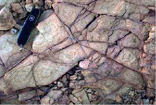
In case of the pictures of these so-called "decorations", they show what are clearly a common geologic feature, Liesegang Banding (rings) which any geologist should have learned about in either their sophomore or junior year in undergraduate school. One example can be seen on the web page, where they have extracts from "the official reports into the excavations at the first known pyramid in Europe" at
http://www.bosnianpyramid.com/index_fil ... rt_en.html
There, it is stated:
"One of the blocks was excavated from a depth of 1.7m.
It was found to have circular patterns which will be
analysed further; it is thought that they are man made."
There is a picture of the circular patterns at:
http://www.bosnianpyramid.com/images/Bo ... sSlabs.jpg
The “circular patterns” in this picture is an undoubted example of natural Liesegang banding (rings). There should be no doubt to any person, who is literate in basic geology, even from a picture, that these circular patterns are natural Liesegang banding, not man-made.
A brief discussion of Liesegang banding (rings) can be found in "Geologic Pattern Formation at
http://wwwitp.physik.tu-berlin.de/~krug/geol_en.html
and in "Stone Images" at
http://www.pgi.gov.pl/pgi_en/index.php? ... le&sid=109
Some pictures of Liesegang banding for comparison, can be found in (1.)
"Liesegang Rings" at
http://www.huddersfieldgeology.supanet. ... /ring1.jpg and
http://www.huddersfieldgeology.supanet. ... 20envi.htm
(2.) "Liesegang banding in Tapeats Sandstone, Deer Creek, mile 136.3. at:
http://www.aapg.org/slide_bank/grand_canyon/72.cfm
(3.) "Fracture-controlled Liesegang banding in siltstone" at:
http://darkwing.uoregon.edu/~millerm/7LM20.jpeg and
http://darkwing.uoregon.edu/~millerm/minfracs.html
(4.) " Liesegang banding in Unkpapa Sandstone, Calico Canyon, Black
Hills, South Dakota" at
http://www.geodil.com/images/18/1800/mid.jpg and
http://www.geodil.com/image.asp?ImageID ... egoryid=20
A simple definition of Liesegang Banding (Rings) is:
"1. Secondary, nested rings or bands caused by
rhythmic precepitation within a fluid saturated
rock (AGI, 1983). 2. A small-scale, more or less
concentric, chemical reaction effect, seen as
discrete, but largely contiguous, structures
throughout a part of a rock body. Each structure
shows, on an exposed surface, ring-shaped bands
of concentric colour. The effect is probably caused
by rhythmic precipitation in a gel (a jelly-like
colloidal solution), perhaps a kind of weathering
process........... (Wyatt, 1992)."
Wyatt, A., 1992.. Challinor's Dictionary of Geology.
Cardiff, Wales: University of Wales Press.
Some References About Them are:
Fu, L., Milliken, K. L., Sharp, J. M., Jr, 1994, Porosity
and permeability variations in fractured and liesegang-
banded Breathitt sandstones (Middle Pennsylvanian),
eastern Kentucky; diagenetic controls and implications
for modeling dual-porosity systems. Journal of
Hydrology. vol. 154, no. 1-4, pp. 351-381.
Ortoleva, P. J., 1983, The self organization of liesegang
bands and other precipitate patterns. In G. Nicolis-G and
F. Baras, eds., pp. 289-297, Chemical instabilities;
applications in chemistry, engineering, geology, and
materials science. NATO ASI Series. Series C:
Mathematical and Physical Sciences. no. 120; D. Reidel
Publishing Company. Boston.
Shahabpour, J., 1998, Liesegang blocks from sandstone beds
of the Hojedk Formation, Kerman, Iran. Geomorphology.
vol. 22, no. 1, pp. 93-106.
Yours,
Paul H.

 Barakat found the tunel , i think


