The ups and downs of Archaeology

Random older topics of discussion

Moderators: MichelleH, Minimalist, JPeters

Beagle
Posts: 4746
Joined: Fri Apr 14, 2006 2:39 am
Location: Tennessee

Post by Beagle »

The South of England is actually starting to tilt downwards as the North rises upwards
I'm familiar with the "isostatic rebound" of post glacial areas, but I didn't realize that it was still happening in the UK.

Thanks Mike.
User avatar
Digit
Posts: 6618
Joined: Tue Oct 31, 2006 1:22 pm
Location: Wales, UK

Post by Digit »

Here is a weather report for May AD 10000! Southern England has just vanished beneath the sea and the fare to France due to the increased distance will now be 10,000,000 Euros.
Those looking for a cheaper away day might like to use their bicycles to journey to Norway along the newly emerged land bridge.
Mike Jupp
Posts: 41
Joined: Fri Mar 10, 2006 8:30 am
Location: West Sussex. England
Contact:

Post by Mike Jupp »

Thanks Cognito!
I may not have those photos yet, but one local offshore mystery was solved recently.
Next to the Lifeboat Station at Selsey Bill (Just down the Coast from me)
is an 80' hole called the 'Mixon (The bottom right dot. The top red dot is the site of Fishbourne Roman Palace)
Image

'The area around Selsey Bill was dry land 2000 years ago and the site was thought to have once been the mouth of a river. Archaeologists have traced the remains of a Roman road which connects with the existing Chichester road as well as an old quarry. The Mixon Hole, as the dive is called, is more like a basin now and is geologically fairly odd.
The seabed around the Mixon is 6-8m deep and much of it dries out on a low-water spring, but the hole descends steeply to about 26m. The top of the reef is covered in algae and fish life, but once over the lip the rock face is barren.
Archaeologists believe that the Mixon had a Roman fort on top, because stones in the wall appear to have been cut by human hand. The sides are straight and the corners at right angles. And on the bare, almost flat seabed sit several huge, rounded stones, thought by some to have come from a catapult inside the fort - a Roman artillery piece.
- Gavin Parsons
http://www.divernet.com/cgi-bin/article ... on=display


..And here, is one of the 'missiles'
Image
Last edited by Mike Jupp on Mon Nov 27, 2006 4:20 pm, edited 1 time in total.
RETRIBUTION!!!!!
http://www.webnet2000.com/mikejupp/viewtopic.php?t=54
Si vis pacem...Parabellum!
User avatar
Barracuda
Posts: 351
Joined: Thu Dec 01, 2005 2:02 pm
Location: Northern California

Post by Barracuda »

Hi, Mike!

As a former SCUBA diver and general beach bum/kayaker/surfer I find the subject of moving coastlines very interesting. The west coast of England is considered one of the most challenging seascapes in the world. Water temps are very cold, and visibility is very limited.


I think some of this research would be really useful in the eastern Mediterranean where diving conditions might better lend themselves to research... And hot German tourist girls in bikinis...
Mike Jupp
Posts: 41
Joined: Fri Mar 10, 2006 8:30 am
Location: West Sussex. England
Contact:

Post by Mike Jupp »

Hi Barracuda and fellow Diver! (though ex-Diver in my case!)
I've always regretted not knowing then what I know now! I did several training dives near the Mixon, but didn't know of its existence back then.

I've dived off Dorset in the West Country...I do remember kelp beds and, like you said, I remember how cold the water was, even with thermals and a wet suit!!
On the other hand, it's usually..the colder the clearer! around the English Channel.

Talking of which!...Here's a question for you!
About a mile from the beach of my home town of Bognor Regis, the seabed is sandy with beds of exposed Jurassic 'London Clay'. The bay is decorated with the occasional rocky 'erratic'.
The water is about 60' deep, and I remember finding hundreds of long green metal cylinders scattered all over the place. They were about 5" long x .5" wide, and hollow. Any ideas?

(I also remember finding an outboard motor stuck upright in the seabed?..I bet they had fun getting home!)
:lol:

Oh!..and whereabouts in Northern California Barracuda ?
I used to live in Novato, Marin (off 101)
RETRIBUTION!!!!!
http://www.webnet2000.com/mikejupp/viewtopic.php?t=54
Si vis pacem...Parabellum!
stan
Posts: 924
Joined: Mon Jan 23, 2006 8:00 pm
Location: USA
Contact:

Post by stan »

Hello, Mike Jupp.

We have a had a few discussions of underwater archaeology on this board.
Some of us are especially intrigued by the possibilities along the west coast of the US, which may contribute to the understanding of the peopling of the Americas. (OK...east coast, too!)
But it seems a daunting task, with pounding surf and maybe
300 ft of water on top of whatever might be left...
any thoughts?
I know a lot is happening in England in this regard.
The deeper you go, the higher you fly.
Mike Jupp
Posts: 41
Joined: Fri Mar 10, 2006 8:30 am
Location: West Sussex. England
Contact:

Post by Mike Jupp »

Hi Stan!
Whereabouts on the 'West Coast'? I'm no expert, but I wouldn't have thought that there were any large ancient stone stuctures in the Americas until you get to the extreme South West?

Talking of floods!....

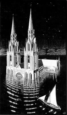
I don't know whether you've ever heard it, but there's a piece of music by Claude Debussy about a drowned Cathedral!
Here's an extract from Wikipedia about this alleged 'Drowned Cathedral'

Ys (also spelled Is or Ker-Ys in Breton) is a mythical city built in the Douarnenez bay in Brittany by Gradlon, King of Cornouaille, for his daughter Dahut.

'According to the legend, Ys was built below sea level, protected from inundation by a dam. The only keys of the gate in the dam were held by Gradlon, but Satan made Dahut steal them and give them to him. He then opened the gate and Ys was flooded. In some versions of the story, Satan was sent by God to punish the city, whose inhabitants were becoming decadent. Other versions of the story tell that Dahut stole the keys either at her lover's request or in order to open the gates of the city to let her lover in. The only survivors were the King Gradlon, who was advised to abandon his daughter and Saint Winwaloe by Saint Winwaloe himself. Gradlon then founded Quimper and on his death, a statue representing him on horseback looking in the direction of Ys was erected on the Saint Corentin Cathedral and still stands there. Bretons said that Ys was the most wonderful city in the world, and that Lutèce was renamed Paris after Ys was destroyed, because "Par-Is" in Breton means "Similar to Ys".

This deluge legend differs from others because the location of Ys is well defined: the statue of Gradlon looks at it, most of the localities mentioned exist, several Roman roads actually lead into the sea (and are meant to lead to Ys), and this myth could in fact depict the engulfment of a real city during the 5th century. This history is also sometimes viewed as the victory of Christianity (Gradlon was converted by Saint Winwaloe) over druidism (Dahut and most inhabitants of Ys were worshippers of Celtic gods). However, a Breton folktale asserts that Gradlon met, spoke with and consoled the last Druid in Brittany, and oversaw his pagan burial, before building a chapel in his sacred grove.


"So what?...Stoopid Limey!"...I hear you cry!

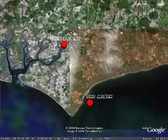
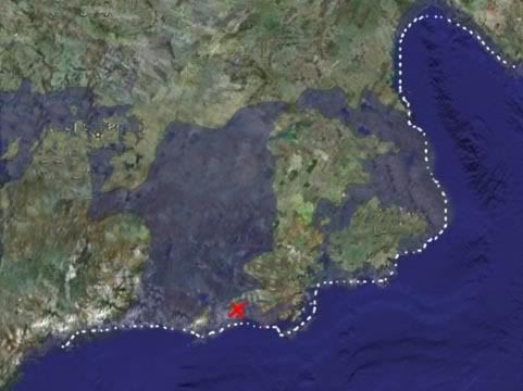
Well...my previous posting about 'Selsey' is a possible answer to the legend..
'Sel-sey' means 'Seal Island'. An undeniable fact is that there was a substantial Roman Port there (now under the sea)..Wherever there was a Roman settlement, there would have been a Temple. It is known that there was an early Christian settlement on 'Seal Island'
They would have been Romano-British Christians before assimilating with the Saxons.
The sea DID inundate that building, and the centre of worship was transferred to CHICHESTER (NOVIOMAGVS REGNORVM)
The Cathedral was begun in the early 1100's after the Norman invasion. If you look carefully at the outside of the cathedral (and I did recently) you can clearly see incorporated Roman brick and odd shaped stone. A lot of it came from the nearby Fishbourne Roman Palace (destroyed by fire in the 4th Cent.)

Since reading your post Stan, I've found out that 'Mixon' actually refers to a type of Limestone. The quarry at Selsey now appears to be VERY important!
I've discovered that it was used in the building of Fishbourne Palace and many buildings in the principle Roman city of NOVIOMAGVS REGNORVM (Chichester) It was still being mined as late as the 11th Century..
Then the sea came!

This is is a fanciful theory by me...but is it just coincidence that the 'SEY' of 'Selsey' is a similar sound to the Breton 'Ys'?...and is the mention of battles with Satan a bit of allegory over Christianisation of the Romans in the area during the late 3rd century?

Anyway, the legend, both here in Sussex and over there in Brittany, is that on Stormy nights, the bells of the sunken 'Cathedral' can still be heard! (all true of course!)
http://www.roman-britain.org/places/nov ... gnorum.htm
Image
RETRIBUTION!!!!!
http://www.webnet2000.com/mikejupp/viewtopic.php?t=54
Si vis pacem...Parabellum!
User avatar
Manystones
Posts: 260
Joined: Thu Oct 26, 2006 5:21 am
Location: Watford, England
Contact:

Re: The ups and downs of Archaeology

Post by Manystones »

Mike Jupp wrote:But can anyone tell me why my next theory is wrong?
I reckon our ancestors just followed the coastline in search of food!
It's that coastline that would have been radically different 10-12,000 years ago. I've done a VERY rough image of a possible prehistoric coastline. The interesting thing is that Neolithic settlements in both the Orkneys and Western Ireland are close to this 'Shoreline'!
The Red cross on the map below indicates Skara Brae http://www.scotshistoryonline.co.uk/scara1.html
Image
IF, I'm right??? Shouldn't we be looking along this '
line' for more settlements?
Mike, I think you could be right about our ancestors following the coastlines.. but I am unsure how you reached your conclusions regarding that particular "prehistoric" coastline scenario? My understanding - and I could well be wrong - is that the present coastline has remained pretty much the same for the last one million years (save for the thames changing direction and course) more or less - given the rise and fall of sea levels between ice ages..

I am guessing that often the same places were inhabitated in Palaeolithic through Mesolithic and then Neolithic times - essentially the high grounds relative to sea levels? Could it just be as simple that the evidence of ancient activity is more abundant than previously thought?

A thought provoking post with some interesting information, welcome to the forum.
stan
Posts: 924
Joined: Mon Jan 23, 2006 8:00 pm
Location: USA
Contact:

Post by stan »

Mike, I enjoyed your post about "La Cathedrale Engloutie"...I know that piece well.

During the last glacial Maximum, it is said that the sea level was around 300 feet lower, with all that water tied up in ice.
this would have allowed Asians to walk over a big landbridge and down the Pacific coast where they could have easily survived on seafood. We aren't talking large-scale architecture here, more like fire pits, middens, toolmaking sites, and so on. But maybe there were some wooden structures as there are at Monte Verde, or possible rock structures.
Question is, is it possible to find these things since
the sea came in
, as you said.
It seems that underwater archeology is the new frontier....

Oh, BTW, why are your maps upside down?...Am I missing something?
Stan
The deeper you go, the higher you fly.
User avatar
Barracuda
Posts: 351
Joined: Thu Dec 01, 2005 2:02 pm
Location: Northern California

Post by Barracuda »

Hi, Mike!

Haven't any idea what the cylinders were for. Did they look like they could have been used for welding, or cutting? A lot of welding cylinders are for one time use.

I live in Modesto California, but I spend my weekends in the mountains in summer, and on the coast in winter. Both are very close, and I have what you in the UK call a caravan. Basicly a big bed on wheels

I haven't ever done any diving in California. I quit that when I moved out here from Florida. The water is too cold and the visibility too poor.
Mike Jupp
Posts: 41
Joined: Fri Mar 10, 2006 8:30 am
Location: West Sussex. England
Contact:

Post by Mike Jupp »

Hi Barracuda!
I don't blame you for quitting...The first thing I did when I got to S(t?)impson Beach was to put my hand into the Pacific to say to myself, "I've done that"...Then I said to myself "Bloody hell!..That's cold!!!"

The cylinders?...20mm cannon shells! There was a mass of aerial activity around here from 1939-45
We've got at least half a dozen ex WW2 Airfields around here! (Including an AMERICAN SPITFIRE SQUADRON!! (The 31st Fighter Group)
..AND, the grave of BILLY FISKE!..The first American HERO to die in service with the RAF. (God Bless you Billy!!... And yes, I've put flowers on his grave!)

He's buried at Boxgrove Priory. (The same Boxgrove where Heidelberg Man's activities have been discovered!)
That gave me the inspiration for this painting (The American Airmen, not Heidelbergwotsit Man!)
I called the illo, 'Summer Shadows' (A shameless bit of self publicity now follows!)

Image
Last edited by Mike Jupp on Wed Nov 29, 2006 2:50 am, edited 3 times in total.
RETRIBUTION!!!!!
http://www.webnet2000.com/mikejupp/viewtopic.php?t=54
Si vis pacem...Parabellum!
Mike Jupp
Posts: 41
Joined: Fri Mar 10, 2006 8:30 am
Location: West Sussex. England
Contact:

Post by Mike Jupp »

Hi Stan,
I put the maps 'upside down' because we're all conditioned to a chauvenistic view of things.
When I had cleansed my mind (not difficult) of seeing things that we in the 21st Century have been conditioned to seeing them..The World becomes a different place, with different (pre-historical) perspectives?
RETRIBUTION!!!!!
http://www.webnet2000.com/mikejupp/viewtopic.php?t=54
Si vis pacem...Parabellum!
stan
Posts: 924
Joined: Mon Jan 23, 2006 8:00 pm
Location: USA
Contact:

Post by stan »

That's your prerogative! I Thought something was wrong with your computer. :)
The deeper you go, the higher you fly.
Mike Jupp
Posts: 41
Joined: Fri Mar 10, 2006 8:30 am
Location: West Sussex. England
Contact:

Post by Mike Jupp »

The only thing wrong with my computer is the operator! :oops:
RETRIBUTION!!!!!
http://www.webnet2000.com/mikejupp/viewtopic.php?t=54
Si vis pacem...Parabellum!
Mike Jupp
Posts: 41
Joined: Fri Mar 10, 2006 8:30 am
Location: West Sussex. England
Contact:

Post by Mike Jupp »

Hi Stan,
You wrote,
"this would have allowed Asians to walk over a big landbridge and down the Pacific coast where they could have easily survived on seafood."
I listened to the recent Archaeologica broadcast that mentioned the fact that the Bering Land Bridge might not have been the only access to the Americas.
That makes sense and would explain the Negro head sculptures of the Olmeca 'Indians'.
I've got a documentary following a French team of Archaeologists. Their DNA survey lead them all the way south to Tierra Del Fuego, to the last remaining ancestors of 'Negro/African' aboriginals. If I remember correctly?..They shared DNA with modern Australian Aboriginals. The hypothisis being that Ocean currents played a part in the original populating of South America
(Back to the Rio Romans debate!)
According to their forensic evidence, these original inhabitants were wiped out/assimilated by warlike mongol races filtering down from the North.
Fascinating! :shock:
Ancient soccer fans? Didn't the Aztecs have a version of soccer using the heads of their enemies as 'balls'? (could've been worse, could've been the other way around! :D )
RETRIBUTION!!!!!
http://www.webnet2000.com/mikejupp/viewtopic.php?t=54
Si vis pacem...Parabellum!
Locked