
Of course it's a worst case scenario Monk, nothing else makes the head lines. Can you imagine a head line saying, 'look forward this year folks to a lovely mild summer!'?
Marvel comics would sell more issues.
Global warming.
Moderators: MichelleH, Minimalist, JPeters
-
Charlie Hatchett

- Posts: 2274
- Joined: Wed May 17, 2006 10:58 pm
- Location: Austin, Texas
- Contact:
Charlie, stay where you are because you will own precious beach front property. Those poor folks walking down Beal Street in Memphis will need snorkel gear, however:
Monk, if these artifacts come in confirmed at 147,500 B.P. (Sangamonian Interglacial), these guys may have been living very close to the coast. Anyway to find out projected water coverage during the Sangamonian?
Charlie Hatchett
PreClovis Artifacts from Central Texas
www.preclovis.com
http://forum.preclovis.com
PreClovis Artifacts from Central Texas
www.preclovis.com
http://forum.preclovis.com
-
Forum Monk
- Posts: 1999
- Joined: Wed Dec 27, 2006 5:37 pm
- Location: USA

Sangamonian
Charlie, the following article would indicate that the highstand at the Sangamonian occurred about 131kya and was 12.5 to 16 meters higher than present. Run Min's program and you'll get your answer.Monk, if these artifacts come in confirmed at 147,500 B.P. (Sangamonian Interglacial), these guys may have been living very close to the coast. Anyway to find out projected water coverage during the Sangamonian?
http://jsedres.sepmonline.org/cgi/conte ... t/69/2/317
Natural selection favors the paranoid
-
Charlie Hatchett
- Posts: 2274
- Joined: Wed May 17, 2006 10:58 pm
- Location: Austin, Texas
- Contact:
Re: Sangamonian
I dunno Charley, the maps I posted represented 80m above present sea-levels, obviously quite high. If we can determine the approx water level with respect to today's 'normal' we may be able to simulate it. I believe Minimalist posted a link to just such a tool, not long ago.
Yeah, knowing how far inland these peeps were would be an interesting tidbit to know. Virginia hinted at the notion some of these artifacts could be of Illinoisan age or greater. If I recall correctly, there was an interglacial prior to the Illinoisan. Not sure if it's named or not.Cognito wrote:Charlie, the following article would indicate that the highstand at the Sangamonian occurred about 131kya and was 12.5 to 16 meters higher than present. Run Min's program and you'll get your answer.Monk, if these artifacts come in confirmed at 147,500 B.P. (Sangamonian Interglacial), these guys may have been living very close to the coast. Anyway to find out projected water coverage during the Sangamonian?
http://jsedres.sepmonline.org/cgi/conte ... t/69/2/317
Min, where's that program of yours?
Charlie Hatchett
PreClovis Artifacts from Central Texas
www.preclovis.com
http://forum.preclovis.com
PreClovis Artifacts from Central Texas
www.preclovis.com
http://forum.preclovis.com
-
Forum Monk
- Posts: 1999
- Joined: Wed Dec 27, 2006 5:37 pm
- Location: USA
Look at Min's post here Charlie (go to the top of the page):
http://archaeologica.boardbot.com/viewt ... ght=#28697
http://archaeologica.boardbot.com/viewt ... ght=#28697
-
Charlie Hatchett
- Posts: 2274
- Joined: Wed May 17, 2006 10:58 pm
- Location: Austin, Texas
- Contact:
Monk, would you mind running it at 29 meters, per Pat's report of pre-Illinoisan sea levels?Forum Monk wrote:Look at Min's post here Charlie (go to the top of the page):
http://archaeologica.boardbot.com/viewt ... ght=#28697
Charlie Hatchett
PreClovis Artifacts from Central Texas
www.preclovis.com
http://forum.preclovis.com
PreClovis Artifacts from Central Texas
www.preclovis.com
http://forum.preclovis.com
-
Forum Monk
- Posts: 1999
- Joined: Wed Dec 27, 2006 5:37 pm
- Location: USA
Using this tool, which Min posted:
http://merkel.zoneo.net/Topo/Applet/
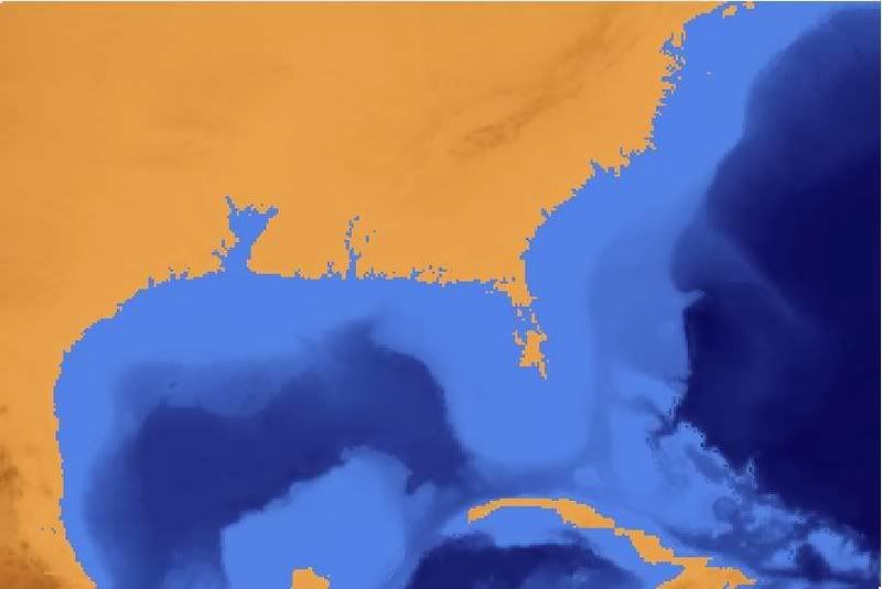
I produced this image which I color enhanced for clarity. It the eastern US at 29meters. Unfortunately, this version does not give you landmarks other than topography.
http://merkel.zoneo.net/Topo/Applet/
I produced this image which I color enhanced for clarity. It the eastern US at 29meters. Unfortunately, this version does not give you landmarks other than topography.
-
Charlie Hatchett
- Posts: 2274
- Joined: Wed May 17, 2006 10:58 pm
- Location: Austin, Texas
- Contact:
Thanks Monk.Forum Monk wrote:Using this tool, which Min posted:
http://merkel.zoneo.net/Topo/Applet/
I produced this image which I color enhanced for clarity. It the eastern US at 29meters. Unfortunately, this version does not give you landmarks other than topography.
Yeah, it would be helpful if the program displayed at least the major rivers.
Charlie Hatchett
PreClovis Artifacts from Central Texas
www.preclovis.com
http://forum.preclovis.com
PreClovis Artifacts from Central Texas
www.preclovis.com
http://forum.preclovis.com
Saved me mentioning rivers Charley. People go on about sea level rises without seeming to understand what effect that would have on rivers.
First off the tidal distance up stream will increase, secondly the flow rate of the river will decrease untill the level rises above the bank height, thirdly sedimentation patterns will change, fish breeding grounds may move upstream and some spawning grounds could disappear under sediments.
But, and it's a big but, we have been there before and nature tends to adapt just as we do, and I'm still waiting for the experts to explain how the Polar bear, Musk Ox, Arctic Fox, various Seals, Walruses, etc etc etc managed the last time all this occured.
Some of these people are only happy when they are miserable.
-
Forum Monk
- Posts: 1999
- Joined: Wed Dec 27, 2006 5:37 pm
- Location: USA
Charlie,
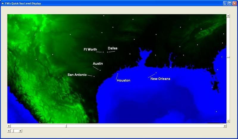
I know you were disappointed in the map which showed Texas at +29 meters sea level. I was too. so I decided to download the topographical data from the USGS website and make my own program for displaying the data. I can do any sea level from -11000 to +8000 meters. I can literally do the biblical flood or drain the ocean. There is distortion since I did not take the time to project the image using a standard orthographic or similar projection. Is like unwrapping the globe and laying it flat, stretched out at the poles.
Here is Texas again at +29meters with some major cities shown for landmarks.
-
ravenwing5910
- Posts: 164
- Joined: Wed Mar 07, 2007 1:36 pm
- Location: Oregon
Hi Guys, I am wondering about the inundation theory. Do you think it would really be too terrible? Isn't it possible that there won't be the dramatic sea level (rivers included) changes, before the conveyor belt is destroyed and we plunge into a glacial period? As for the effects on the populations due to the climate changes I would guess that it would not be too much different than in previous events. Certain species will do fine while others will die out, depending on how specialized they have become. Humans on the other hand I think will suffer the most, we have become quite dependent on the current mild weather systems and any marked change creates havoc for our species with disease, famine, war (you know all that biblical stuff). It is possible that our ancestors handled the last glaciation with alot more grace than we or future generations will.
Morning RV. First of all, there were a lot of more our ancestors than there are of us, just look at Monks map, Houston and New Orleons both look a bit damp!
IF we can establish for certain that these sea level rises will occur then the populations can move, but in some areas of the world that would be very diifficult.
Currently the growing season in the north is increasing and the latitude at which cereal crops can be grown is moving northwards, animal husbandry could be abandoned, thereby realeasing much land to grow vegetable crops.
The conveyor shutting down, what makes you think it will?
Warm air from the tropics has to move towrds the poles, this is why polar regions show a more rapid warming than the tropics, the ocean currents have to do the same.
The Gulf Stream arises in the Carribean and has to flow north and east, it has no choice as long as the present land masses remain as they are. The warmth of the Gulf Stream is solar induced and the local sea level rises due to thermal expansion, after which it escapes eastwards because it is flowing downhill, it then moves northwards because the diameter of the Earth across the poles is less that at the equator, so once again it is flowing downhill.
Could it be deflected by melting ice? The experts say yes, then I ask what happens when the ice has gone?
The Gulf Stream locally pushes the 32F thermocline northwards, without it the western seaboard of Europe would have a climate similar to North America at the same latitude.
-
Forum Monk
- Posts: 1999
- Joined: Wed Dec 27, 2006 5:37 pm
- Location: USA
No.ravenwing5910 wrote:It is possible that our ancestors handled the last glaciation with alot more grace than we or future generations will.
IMO they handled it just fine and so will we. Perhaps better because we have better technology.
The interesting thing for me is how these ancestors survived. I have no doubt they were capable of not freezing to death. The worse problem they would have dealt with is gathering food. Obviously food would have been much more scare on frozen ground but around the sea, plenty of food thrives in icy waters.