Forum Monk wrote:Charlie,
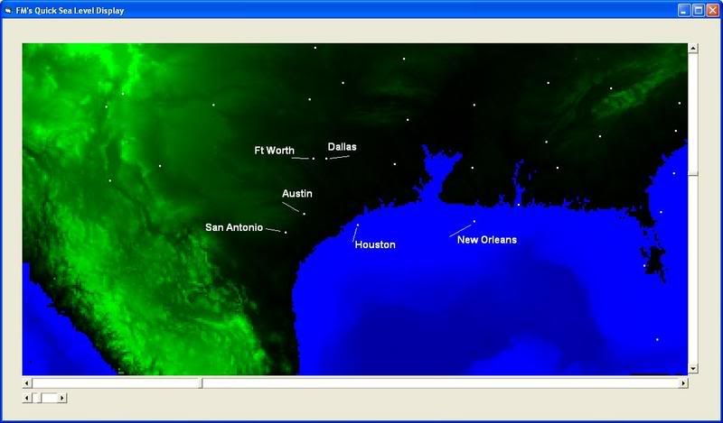
I know you were disappointed in the map which showed Texas at +29 meters sea level. I was too. so I decided to download the topographical data from the USGS website and make my own program for displaying the data. I can do any sea level from -11000 to +8000 meters. I can literally do the biblical flood or drain the ocean. There is distortion since I did not take the time to project the image using a standard orthographic or similar projection. Is like unwrapping the globe and laying it flat, stretched out at the poles.
Here is Texas again at +29meters with some major cities shown for landmarks.
Thanks Monk!
A little rough interpolation puts the coast about 125 nm from the site if sea levels rose 29 meters. It's currently ca. 175 nm.
Would you mind running a scenario where the coast runs just a tad (maybe 30 miles) east of Austin.
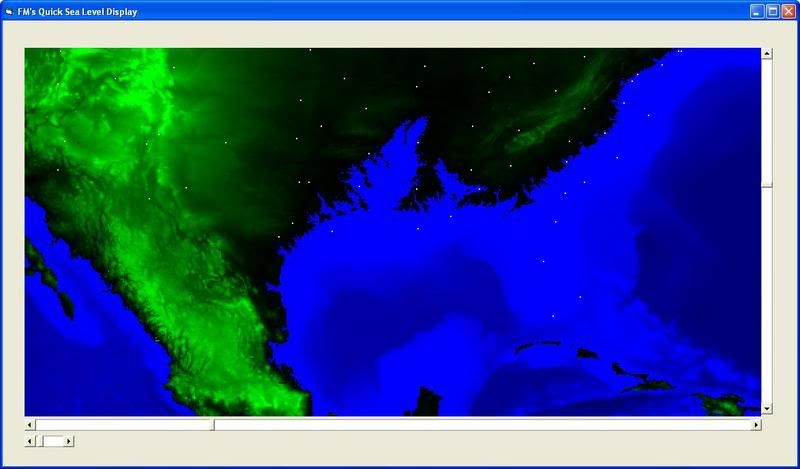
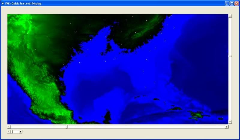
Here are two relative scenarios using the same city marks as shown on the previous image.
Texas with sea level at +85m:
Texas with sea leve at +115m
Somewhere around 100+m you start to the ocean near Austin. Give me the elevation of your site and you will know for sure.
I don't know where your little creek bed runs but at one time it could have been a major river which would not need to have ocean neraby to support an aquatic life-style. Rivers are actually very dynamic, often changing course and size many times, influenced by many factors from earthquakes and plate tetonics to weather conditions.
The bed elevation is around 620'. The banks, 650'. About 10-15 miles east, the elevation drops to 500'. Were I'm investigating is the very edge of the Edwards Plateau/ Balcones Escarpment. The creek is a tributary to the Brazos, which drains into the Gulf of Mexico ca. 175 nm SE. If you look at the recently exposed limestone bed, you can tell at one time this sucker uses to move some water:
In hydrodynamics Charley it is not generally realised that doubling the flow speed of water increases the weight it can move by 16 times. Over here people who should know better have not infrequently attempted to change water courses and then had to live, indeed die, with results of their efforts.
Charlie, there are three fault zones running along the eastern edge of the Balcones; Talco fault near Texarkana; Mexia fault near - well, Mexia and Waco and Lulling just east of SanAntonio. At various times its been a geologically active area. Although apparently not within the last 15000 years or so http://www.lib.utexas.edu/geo/balcones_ ... eface.html
Looking back at the Texas at +115 meters map, the edge of the water more or less follows the Balcones line from San Antonio to Dallas. However, present estimates say that if the polar ice caps should completely melt down to nothing, the rise in sea level would be 80 meters. So, unless a whole lot of water went subterranean, I doubt if sea levels were ever, anywhere near these values.
Digit wrote:In hydrodynamics Charley it is not generally realised that doubling the flow speed of water increases the weight it can move by 16 times. Over here people who should know better have not infrequently attempted to change water courses and then had to live, indeed die, with results of their efforts.
Boy, we see it all the time here. The newscasters have a pet phrase: "Turn around, don't drown". Central Texas is one of the worst flash flood zones in N.A. Water is going to find it's way to the lowest point
eventually.
Forum Monk wrote:Charlie, there are three fault zones running along the eastern edge of the Balcones; Talco fault near Texarkana; Mexia fault near - well, Mexia and Waco and Lulling just east of SanAntonio. At various times its been a geologically active area. Although apparently not within the last 15000 years or so http://www.lib.utexas.edu/geo/balcones_ ... eface.html
Looking back at the Texas at +115 meters map, the edge of the water more or less follows the Balcones line from San Antonio to Dallas. However, present estimates say that if the polar ice caps should completely melt down to nothing, the rise in sea level would be 80 meters. So, unless a whole lot of water went subterranean, I doubt if sea levels were ever, anywhere near these values.
Yeah, that's what I was toying with. To the west of the fault zone is the Hill Country. To the east, the Blackland Prairies. Of course there were oceans bumping up against the fault during the Early Miocene:
Interesting discussion but the real question is, as R/W mentioned, how much fresh water can you dump into the ocean before the conveyor breaks down and triggers the ice to advance? And, how much human misery will be caused by even a minor increase in sea level? A one-meter increase may not bother the US too much but it could be disastrous in Bangladesh.
Something is wrong here. War, disease, death, destruction, hunger, filth, poverty, torture, crime, corruption, and the Ice Capades. Something is definitely wrong. This is not good work. If this is the best God can do, I am not impressed.
There was some sediment analysis released a few years ago that came to that conclusion.
I'll go look around for it.
Something is wrong here. War, disease, death, destruction, hunger, filth, poverty, torture, crime, corruption, and the Ice Capades. Something is definitely wrong. This is not good work. If this is the best God can do, I am not impressed.
The scenario he laid out goes like this: Increasing rainfall and melting ice caused by global warming could lead to a buildup of fresh water in the North Atlantic. That influx could shut down circulating ocean currents that normally draw warm salty water from the tropics along with vast amounts of heat.
Stopping those currents might disrupt the redistribution of heat around the globe. In fact, there is evidence that Atlantic currents may already be under pressure. A few months after the Chicago meeting, British scientists writing in the journal Nature showed that salinity has dropped measurably in the North Atlantic during the past 40 years. The Woods Hole graphics department turned the data into an interactive program that Dr. Curry e-mailed to Mr. Comer.
Something is wrong here. War, disease, death, destruction, hunger, filth, poverty, torture, crime, corruption, and the Ice Capades. Something is definitely wrong. This is not good work. If this is the best God can do, I am not impressed.
Logically going from A to B to C I reason it like this Min. If the fresh water stops the conveyor then once that happens the northern latitudes will drop in temp and the 32F thermocline will once again move south. The suggestion is that this would trigger the ice to increase, ok, so the fresh water stops.
As long as the sun heats the Carribean and the Earth continues to rotate in its present direction the warm water has to to flow out of the Carribean and move north east. This would appear therefore to be an oscillating series of events over which we probably have no control.
Our posts crossed there. One of the problems with too many scientists is that they insist on working on a human time scale. So the conveyor is weakening, fine, does that mean it is weakening below some long term average or has it been unusually strong in recent years. Without reference to long term figures the statement is of little help to us. And I again point out that the logical deduction must be that once the conveyor stops so must the flow of fresh water! That being the case then the conveyor would logically restart.
One of the problems with too many scientists is that they insist on working on a human time scale.
I think we are stuck with that. People don't care about anything that is unlikely to affect them or their children.
And I agree completely with your prior post. These things will happen as part of the natural cycle of things...even Gore acknowledges that. The question is, are we accelerating things by our presence/behavior? I imagine we are but again, are we increasing it beyond that "human time scale" concept? I don't know if we have that ability.
Something is wrong here. War, disease, death, destruction, hunger, filth, poverty, torture, crime, corruption, and the Ice Capades. Something is definitely wrong. This is not good work. If this is the best God can do, I am not impressed.


