Nice map. I never saw it before.
So, he was at the high point of the crossing.
And assuming from the arrow angle, we can guess he was running up and away from his attacker when shot.
Now, chased or ambushed?
And if ambushed, on which side of the crest? (Maybe he got over the top, got into his fight, and got shot while running for home?)
And why not robbed?
Why all the top of the line mountian gear if he was a lowlander?
I do not recall the amount of wear on his gear. Boots, etc. Was this a first trip?
otzi
Moderators: MichelleH, Minimalist, JPeters
I just talked to a friend of mine who is into bow hunting.
Traditional bows, not the modern ones with all the cams and pulleys.
He says the bow hunting magazines he buys have had an article I every issue for years on Otzi.
I will have to see if I can get some of his old issues and do some research.
I may be intresting to get the view of some guys that actually go out into the woods and use a bow and arrow.
-
Rokcet Scientist
Neither did I.kbs2244 wrote:
Nice map. I never saw it before.
He was at the high point of his crossing!
So, he was at the high point of the crossing.
He could have chosen much lower passes. Like everybody else does/did. But he didn't. Why? Maybe because he was lost. Could make sense since it looks like he was in unfamiliar terrain? Or maybe he didn't take the low road because he was on the run and trying to avoid running into people. Or both (my opinion)!
Why might that be important?
And assuming from the arrow angle, we can guess he was running up and away from his attacker when shot.
Now, chased or ambushed?
And if ambushed, on which side of the crest? (Maybe he got over the top, got into his fight, and got shot while running for home?)
The terrain mandated it.
And why not robbed?
Why all the top of the line mountian gear if he was a lowlander?
And (my conjecture) so he stole it while on the run. Possibly hitting someone over the head in a robbery for it. That victim's associate(s) got mad, pursued him, ever higher up the mountain, and finally, but inevitably, caught up with Oetzi and avenged his/their kin.
If no wear was reported on the gear it may be because the gear was relatively new. Then it could have been a 'first trip' for the gear. It doesn't say anything about Oetzi's experience, or lack of it, in the high mountains.
I do not recall the amount of wear on his gear. Boots, etc. Was this a first trip?
Don't forget 3,210 meters is FUCKING high up! It is FUCKING dangerous to be there.
Nobody goes there unless for really, really important reasons.
[/u]

-
Rokcet Scientist
I dunno if it was 'just a couple on a wekend hike'. But it certainly was 5,000 years later!kbs2244 wrote:You keep talking about how high it is, and it is certinly higher than I have ever been, but wern't the people who made the discovery just a couple on a wekend hike?
If it was 'just a couple on a wekend hike', they probably drove – by car – to 1,800/2,000 meters and then took a ski lift to about 3,000 meters, and only THEN started hiking. Thousands of people do that every year. I did. About 2 dozen times. My object was to reach the highest point from which I would decend. On ski's! That was easy. Gravity does the work.
But the walk from the ski lift, at 3,500 meters, to the point where you push off for your downhill track, was about 200 meters. And basically level. Yet that seemingly negligible distance caused me (and everybody else), all lowlanders, to pause every 10 steps, for a few minutes, to catch my (our) breath: lack of oxygen. There is no way in hell a lowlander can maintain a steady pace at that altitude. That's why it takes 5 weeks to scale Everest.
Oetzi was faaaar into the danger zone. Running gigantic risks. Even without being attacked it is doubtful he would have survived that 'trip'. Especially as he seems to have been inexperienced in that difficult terrain.
-
Minimalist
- Forum Moderator
- Posts: 16046
- Joined: Mon Sep 26, 2005 1:09 pm
- Location: Arizona
The first time I went to the Grand Canyon, elevation about 7,000 feet, after living my whole life basically at sea level, I thought my lungs were on fire after about a hour of just walking along the rim. The second time was easier.
Something is wrong here. War, disease, death, destruction, hunger, filth, poverty, torture, crime, corruption, and the Ice Capades. Something is definitely wrong. This is not good work. If this is the best God can do, I am not impressed.
-- George Carlin
-- George Carlin
-
Rokcet Scientist
Going by that NG image ('map'), that Beagle posted a link to, I tried to pinpoint with Google Earth, near as I could, the location where Oetzi was found. I think I identified the ridge/crest. But that ridge/crest is about 8 miles long, between the pin and the Austrian border. That's as the crow flies, so on foot it could easily be 30 or 40 miles.
Of course in Oetzi's days, there wasn't an Austrian border! But the present day border seems to follow the terrain, and where the ridge intersects with it looks like the highest summit in the vicinity. The highest summit is also the least accessible point. For people. Pursuers. A quality someone on the run could be focused on, looking for, and thus be going for. That summit might have been his direct goal.
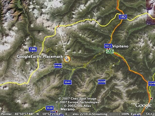
Does anybody have a more precise location?
Coordinates?
Of course in Oetzi's days, there wasn't an Austrian border! But the present day border seems to follow the terrain, and where the ridge intersects with it looks like the highest summit in the vicinity. The highest summit is also the least accessible point. For people. Pursuers. A quality someone on the run could be focused on, looking for, and thus be going for. That summit might have been his direct goal.
Does anybody have a more precise location?
Coordinates?
-
fossiltrader
- Posts: 127
- Joined: Sat Aug 20, 2005 1:24 am
co-ordinates.
These i saw listed but cannot guarantee accuracy?
46 46' 44'' N 46.778889
10 50' 23'' E 10.839722
As i said not sure of accuracy.
46 46' 44'' N 46.778889
10 50' 23'' E 10.839722
As i said not sure of accuracy.
-
Rokcet Scientist
Re: co-ordinates.
Neither am I, because that is on the Austrian side of the border . . .fossiltrader wrote:These i saw listed but cannot guarantee accuracy?
46 46' 44'' N 46.778889
10 50' 23'' E 10.839722
As i said not sure of accuracy.
-
Forum Monk
- Posts: 1999
- Joined: Wed Dec 27, 2006 5:37 pm
- Location: USA
I travelled extensively through the region, the Dolomiti and three-corners region of Austria, Italy and Slovenia. One such trip I found it raining on one mountain, sun shine on the next and so on for mile after mile. I remember seven different rainbows arcing between mountains during that one particularly memorable trip.Digit wrote:You're not on your own chaps, the Austrians and Italians argued like mad as to which side of the border he was found on. As I recall they weren't even sure where the border was!
I also, found that though the border is not always well marked, the locals know exactly where it is. The cultural differences from one side to the next are striking even within the space of a kilometer.
If the arriving authorities did not know where the border was, they needed only to ask a local and would have received an immediate and accurate answer.
-
Rokcet Scientist
I would expect serious researchers to go back to the precise spot where Oetzi was found, record a GPS reading, and take extensive photos of the location, its surroundings, the views from there, and the possible route(s) to that spot. Under a whole variety of circumstances: in summer, in winter, in morning light, afternoon light, twilight, in fog, in a blizzard, etc. etc.
So that the rest of us – armchair (wannabe) scientists – get truckloads of 'ammo' and can juggle all the pieces of that puzzle around into all sorts of possible scenarios of what may have happened. Like an archaeological CSI.
In fact, I expect the 'serious researchers' have done exactly that: a good CSI. But it's almost as if they relish in releasing only broad sketches of scenarios and limited data and photos, so that any serious investigating can only be undertaken by them . . .
Reminiscent of the Dead Sea Scrolls.