The Old World is a reference to those parts of Earth known to Europeans before the voyages of Christopher Columbus; it includes Europe, Asia and Africa.
Gobustan Rock Art Cultural Landscape covers three areas of a plateau of rocky boulders rising out of the semi-desert of central Azerbaijan, with an outstanding collection of more than 6,000 rock engravings bearing testimony to 40,000 years of rock art. The site also features the remains of inhabited caves, settlements and burials, all reflecting an intensive human use by the inhabitants of the area during the wet period that followed the last Ice Age, from the Upper Paleolithic to the Middle Ages. The site, which covers an area of 537 ha, is part of the larger protected Gobustan Reservation.
A UNESCO article about a world heritage site at Gobustan. Located on the shore of the Caspian sea, Gobustan is famous for it's amazing rock art that extends into great antiquity.
Based on the archeological finds and on content of the petroglyphs, recently it has be theorized that a connection exists between the ancient Azeris and the peoples of Scandinavia, which is not surprising at all, since some of the original habitants of the region, the Medes, were not a Turkic people, but an Indo-European people.
Besides being famous for the petroglyphs the Gobustan are also has some amazing landscape, particularly an area filled with mud volcanoes, which provide a quasi-lunar horizon. You can find the most spectacular mud volcanoes about 7km south of Gobustan near the road to Alat.
Dons Maps website has been around for a while. I don't know when this section was included but some of the rock art is now thought to be much older than stated here. Note the high prowed boats.
The rock drawings dating back to remote centuries suggest that the climate of Gobustan in the distant past was damp and close to subtropical. This is evidenced by the pictures of people wearing loin-cloths as being typical of the inhabitants of tropical countries, and also by the representations of bulls, deer, and pigs whose existence is impossible without perennial water reservoirs and rich pastures. Rainfall was heavy enough in those ancient times, rivers and springs abounded in water, the herbage of the area was rich and diverse. An abundance of food made it possible for countless herds of herbivorous animals to graze in the pastures of Gobustan.
There are many articles on Gobustan, it's rock art, and it's mud volcanoes. These are just a few to provide some food for thought. Thor Heyerdahl studied the images of the boats here quite extensively.
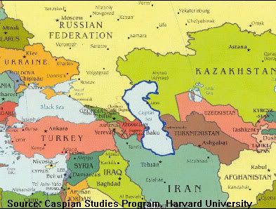
I thought a reference map would be in order, so if you look on the left side of the Caspian sea and find Baku, Gobustan is about 40 miles south of that - on the shoreline.
A dance? Looks as if they are doing the Hokey-Pokey.
Something is wrong here. War, disease, death, destruction, hunger, filth, poverty, torture, crime, corruption, and the Ice Capades. Something is definitely wrong. This is not good work. If this is the best God can do, I am not impressed.
Quite a number of drawings of that period represent boats with both armed and unarmed oarsmen and with an image of the sun on their bows.
Boats?
Something is wrong here. War, disease, death, destruction, hunger, filth, poverty, torture, crime, corruption, and the Ice Capades. Something is definitely wrong. This is not good work. If this is the best God can do, I am not impressed.
Something is wrong here. War, disease, death, destruction, hunger, filth, poverty, torture, crime, corruption, and the Ice Capades. Something is definitely wrong. This is not good work. If this is the best God can do, I am not impressed.
The pictures of goats and, more rarely, deer and horses are crossed by straight furrows dividing their bodies in the middle or cutting off their heads or other parts of the body. The existing ethnographic parallels give good grounds to assume that these furrows were of ritual significance; the primitive people imagined that they would bring them good luck during hunting expeditions.
The furrows were of ritual significance but it was nothing to do with hunting. The horse sacrifice was very common across the whole of that region, and during the horse sacrifice, a goat was also slaughtered.
The rock drawings dating back to remote centuries suggest that the climate of Gobustan in the distant past was damp and close to subtropical. This is evidenced by the pictures of people wearing loin-cloths as being typical of the inhabitants of tropical countries, and also by the representations of bulls, deer, and pigs whose existence is impossible without perennial water reservoirs and rich pastures. Rainfall was heavy enough in those ancient times, rivers and springs abounded in water, the herbage of the area was rich and diverse. An abundance of food made it possible for countless herds of herbivorous animals to graze in the pastures of Gobustan.
So, where do you think they went when the Caspian desiccated? Reed boats, sun worship, etc.
Well, it still would be a short cut for a land based trade route.
I would not be surprised if we find boats went to plank construction and business went on as usual.
I would not be surprised if we find boats went to plank construction and business went on as usual.
Yes, but not in that area. What was once a well-watered inlet of the Caspian Sea became a parched, dry desert where nothing grew. Geologists have documented a 12mm/year tectonic uplift on that shoreline. That's one meter every 83 years. Their homeland went high and dry in ancient times and they moved on.