According to the genetical 'road map' of the 'native Americans' – and this nice young lady – the Americas were populated from north to south, from Beringia to Ushuaïa, along the west coast, in relatively a very 'short time' (a couple of millennia, max).
http://www.youtube.com/watch?v=bsZG0QZypN0
Wanna bet they walked that route?
Although they knew about boating since around 1 million YBP! But they would avoid boating, and walk if they could. And apparently they could: Monte Verde is proof.
Sorry, Min, no boats this time.
And if the American indians' predecessors walked via Beringia to Ushuaïa around 20 to 15 KBP*, then the odds are that the Abos' predecessors walked (to Oz) too, probably between 40 and 60 KBP.
*glacial max was 18 KBP, so that's when sea levels were lowest, continental planes were dry, and land bridges were exposed.
All fit for walking.
Along the coastlines
Moderators: MichelleH, Minimalist, JPeters
-
E.P. Grondine
Re: Along the coastlines
Let me clear this up.
mt C DNA - Iroquoian, via Berringia, around 50,000 BCE, migrating to the tip of South America
mt A DNA - Algonquian hunting sea turtle along the Pacific coast, Siouxian hunting inland along the coastal strip, around 24,000 BCE
mt B and D DNA - by boat across the Pacific from SE Asia, dates unknown, most likely after 60,000 BCE
mt X DNA - accross the North Atlantic at 8,350 BCE
no survivors(Rio cuarto impacts and Great Atlantic Impact Mega-Tsunami impact) - by boat from Sahara River in Africa to Pedra Furada, Brazil, 35,000 BCE
I have been wrong before, and I reserve the right to be wrong both now and in the future.
-
Minimalist
- Forum Moderator
- Posts: 16046
- Joined: Mon Sep 26, 2005 1:09 pm
- Location: Arizona
Re: Along the coastlines
Um, look closely at this map, R/S.

Beringia may have been "exposed" but it was apparently covered by ice.
I really doubt that anyone would have headed for it. Who goes north during an ice age?
Beringia may have been "exposed" but it was apparently covered by ice.
I really doubt that anyone would have headed for it. Who goes north during an ice age?
Something is wrong here. War, disease, death, destruction, hunger, filth, poverty, torture, crime, corruption, and the Ice Capades. Something is definitely wrong. This is not good work. If this is the best God can do, I am not impressed.
-- George Carlin
-- George Carlin

Re: Along the coastlines
What land bridges? Remember, it is you that stated that science was about facts not imagination.
I would also repeat, as in the past, frequently, that you continue to ignore the Andamans and the absence of any land bridge.
Your oft quoted 300 ft sea level drop is insignificant against the abbysal depths surrounding the Andamans and the Wallace line. Also please don't mention the volcanic activity without some evidence, PLEASE!!!!
Roy.
First people deny a thing, then they belittle it, then they say it was known all along! Von Humboldt
Re: Along the coastlines
Precisely Min. RS is relying on low sea levels produced by ice but no ice! Difficult.
Roy.
Roy.
First people deny a thing, then they belittle it, then they say it was known all along! Von Humboldt
-
Rokcet Scientist
Re: Along the coastlines
Um, I know it well, Min: that is exactly the same map I used a couple years ago to illustrate the Solutreans' trek... across the ice!Minimalist wrote:Um, look closely at this map, R/S.
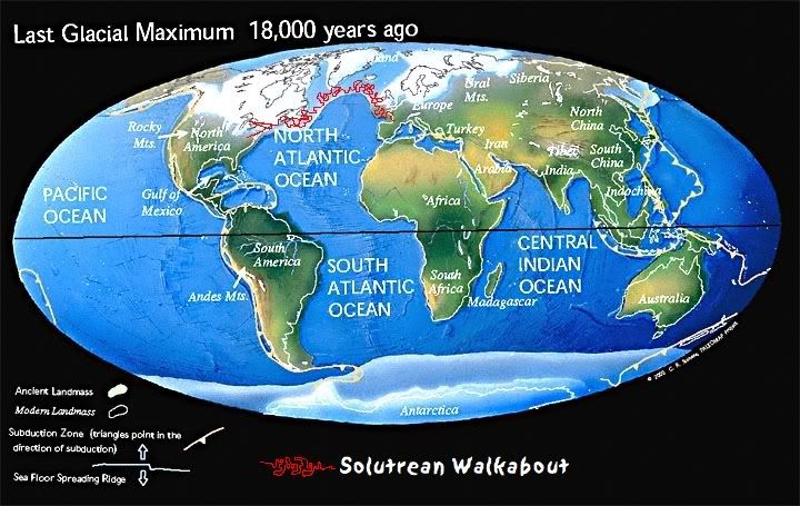
Whatever it was: exposed land or covered with ice, it was traversable on foot! A lot easier than by boating or swimming. Especially when you've got your whole family, with grandparents and kids, trailing you.Beringia may have been "exposed" but it was apparently covered by ice.
Those who know that that's where the easy, protein rich prey is, of course.Who goes north during an ice age?
And it's not just humans. Whales do exactly the same: they go north (in the northern hemisphere anyway; they go south in the other one) every year because in the cold waters is an abundance of food where they stock up on their fat reserves.
Cold seawater = lots of nutrients > lots of marine flora and fauna > abundance of food
Warm seawater = hardly nutrients > much less marine flora and fauna (undersea 'desert') > much less food
Re: Along the coastlines
And no evidence, no acceptance that sea ice can be far from flat and easy to trek along, and again ignoring the Andamans etc. All the old hopeful ideas and ignoring any uncomfortable facts.
And BTW RS Fiennes found man hauling on sea ice dangerous, so now your trekkies are carrying everything!
Roy.
And BTW RS Fiennes found man hauling on sea ice dangerous, so now your trekkies are carrying everything!
Roy.
First people deny a thing, then they belittle it, then they say it was known all along! Von Humboldt
-
Minimalist
- Forum Moderator
- Posts: 16046
- Joined: Mon Sep 26, 2005 1:09 pm
- Location: Arizona
Re: Along the coastlines
I'm trying to think of a single place on the planet where large herbivores dwell on top of a glacier.
Can't think of any.
Can't think of any.
Something is wrong here. War, disease, death, destruction, hunger, filth, poverty, torture, crime, corruption, and the Ice Capades. Something is definitely wrong. This is not good work. If this is the best God can do, I am not impressed.
-- George Carlin
-- George Carlin
-
Rokcet Scientist
Re: Along the coastlines
OK, Roy, because you ask so nicely: here's a map of the major volcanoes and volcanic = tectonic = seismic events, eruptions, in Indonesia in the last 100 years.Digit wrote:please don't mention the volcanic activity without some evidence, PLEASE!!!!

Is the USGS a good enough source for you?
Indonesia is, and was for about the last 50 million years, the most volcanically/tectonically/seismically active region on the face of the planet. It has been jerked up and down, from side to side, and from front to back, creating landbridges and merging islands, or splitting up islands and creating continental divides all the time during that entire era. It's the land of Toba, Tambora, and Krakatoa. And it's all still happening today! It's an on-going process. Panta Rei. Remember the tsunami? Or even more recent: this year Sumatra's already been hit by 2 major 7.7 earthquakes (and hundreds of small ones) and in March there was a big volcano eruption on Java. They could have escaped your attention because it's such a common occurrence that it doesn't get reported in the headlines anymore...
But the fact that they escape your attention doesn't make them happen any less.
Re: Along the coastlines
So what? The is still absolutely no evidence of any land bridges and to conjour up one you have to explain the existance of the Wallace line. It won't go away simply 'cos it's awkward for you.
There remains no evidence of hoofing it to Oz nor the Andamans, and that is a fact!
Roy.
There remains no evidence of hoofing it to Oz nor the Andamans, and that is a fact!
Roy.
First people deny a thing, then they belittle it, then they say it was known all along! Von Humboldt
-
Rokcet Scientist
Re: Along the coastlines
Yeah, like it's a fact that God created the earth 6,000 years ago, and dinosaurs co-existed with Adam and Eve (and Lilith). There's even a whole museum dedicated to it.Digit wrote:So what? The is still absolutely no evidence of any land bridges and to conjour up one you have to explain the existance of the Wallace line. It won't go away simply 'cos it's awkward for you.
There remains no evidence of hoofing it to Oz nor the Andamans, and that is a fact!
You're getting very repetitive, Roy.
The Wallace line wasn't there, at one time. And then (when?) Oz bumped into the SE Asian continental plate and broke it. And Hey Presto! That crack was/is the Wallace Line!
The Wallace Line wasn't always there.
Re: Along the coastlines
I'm getting repetitive? You've been making this totally unsupported claim for years, and we still haven't seen any evidence.

You could win this argument hands down and stop me being 'repetitive' by producing some evidence, over to you!
Roy.
Granted, but it's been there sufficiently long for Oz to develop its own unique fuana, would you care to date that, allowing that you've only got a 6000yr timescale of course.The Wallace line wasn't there, at one time.
You could win this argument hands down and stop me being 'repetitive' by producing some evidence, over to you!
Roy.
First people deny a thing, then they belittle it, then they say it was known all along! Von Humboldt
-
Rokcet Scientist
Re: Along the coastlines
I don't need (more) evidence. Logic fills all the gaps for me.Digit wrote:I'm getting repetitive? You've been making this totally unsupported claim for years, and we still haven't seen any evidence.
Granted, but it's been there sufficiently long for Oz to develop its own unique fuana, would you care to date that, allowing that you've only got a 6000yr timescale of course.The Wallace line wasn't there, at one time.
You could win this argument hands down and stop me being 'repetitive' by producing some evidence, over to you!
FYI: I don't think the route for fauna (including hominids) to Oz went via Bali, Lombok, Sumba, Sumbawa, etc. For me the main route to Papua and Oz went much more northerly, across the continental plane, from Malacca via Borneo/Kalimantan, Celebes/Sulawesi, and the Moluccans. When the Wallace line divide (and the Weber Line divide and the Lydekker Line divide) weren't nearly as wide and deep yet as they are today (It's a continuing process, remember), and thus were still traversable for hominids.
Re: Along the coastlines
But not for Kangeroos, Wombats, Tigers or Elephants RS? Why?and thus were still traversable for hominids.
And why does your 'logic' preclude water craft?
Any evidence for that?weren't as wide and deep yet as they are today
Roy.
First people deny a thing, then they belittle it, then they say it was known all along! Von Humboldt
-
Rokcet Scientist
Re: Along the coastlines
Because they can't boatDigit wrote:But not for Kangeroos, Wombats, Tigers or Elephants RS? Why?and thus were still traversable for hominids.
It doesn't. Hominids developed the first 'watercraft' around 1 million YBP, although those can't have been more than floating trees that they sat on or clung to. By 70,000 BP (around the Toba eruption) that technology had been developing for nearly a million years and was in such a state that the Wallace, Weber, and Lydekker Lines – OF THAT ERA (very much narrower and shallower than they are today!) – could still be traversed.And why does your 'logic' preclude water craft?
weren't as wide and deep yet as they are today
No, I'm not a geologist. So I've got something better: logic. And logic tells me that when the SE Asian continental plane was hit (hard) by the Oz continental plane bumping into it (look at the speed at which Oz moved north!), it caused cracks in it: the Wallace, Weber, and Lydekker Lines. Over time cracks tend to widen. Exactly like when one earthenware pot is bumped into another. The stationary pot cracks first. And those cracks widen over time (even if that time is only a split second).Any evidence for that?