Bosnian pyramids, photos

Random older topics of discussion

Moderators: MichelleH, Minimalist, JPeters

Locked
Ciko
Posts: 168
Joined: Fri Mar 10, 2006 9:19 am

Post by Ciko »

I think this could be more than a pyramid
i dont know what else could it be if the hill look like a giant pyramid and you find such beautiful stone blocks under the soil

Image


and they have found new tnel yester day

Image Barakat found the tunel , i think
Yamemaru
Posts: 36
Joined: Fri Jun 09, 2006 12:02 am

Post by Yamemaru »

yea they found a huge new tunnel, just heard about it on the News.

I am so hoping that this is a Pyramid. I love to see things being discovered, just amazing stuff.
alrom
Posts: 92
Joined: Tue May 23, 2006 2:50 am

Post by alrom »

Image

Ok, I'm very busy but I'll take some time to look closer at this picture. This CAN'T be man-made. Well, sorry, yes it could be man-made but by some stonemason gone completely nuts.

Look at the big stone with that green leave on it. It has a crack going upward and another one going from the top downward. But the cracks don't meet, instead they shape the stone in some kind of N-shape. Who in the hell would carve a pavement stone in that way???

Anyway, I think that I'm preaching to the choir :P

I still don't discard finding stuff there, and some of those pictures could be real manmade pavement but THAT isn't pavement for sure.
Ciko
Posts: 168
Joined: Fri Mar 10, 2006 9:19 am

Post by Ciko »

But the cracks don't meet, instead they shape the stone in some kind of N-shape. Who in the hell would carve a pavement stone in that way???

you should be open minded :D

is it possible that it was a big stone block but broke after some time , yes it could be
stellarchaser
Posts: 225
Joined: Tue Jun 06, 2006 12:17 pm

keep posting Ciko

Post by stellarchaser »

I fully agree with Beagle that Ciko is doing excellent job by posting pics daily and also think that we all should at least respect his time and effort in doing this. And it's simply not fair to pressure him like that.

I'm affraid that whole discussion goes about "believing", which has nothing to do with science. Personally, I also do strongly believe that many wonders are ahead of us regarding Visocica Hill, which shape points to a pyramid. But it's too early to say anything definitive. So why not wait for further data, instead of all this bitterness that goes through this thread.

warm regards from Bosnia,
alex
Guest

reply

Post by Guest »

It would be a damned sight easier to be objective about this thread if Ciko and other believers didn't immediately take offence at anyone daring to be critical of this "eighth wonder of the world". I get the impression that the rest of us aren't allowed to be anything but awe-struck.
stellarchaser
Posts: 225
Joined: Tue Jun 06, 2006 12:17 pm

well

Post by stellarchaser »

anyone has right to his/her opinion, but can't see the point in giving definite answers (positive or negative) while escavations are at the very beginning.

Osmanagich just gave hypothesis that Visococa Hill could be pyramid. He's not an archeologist, but there are two archeologists working on the site. And in the fact that he is not an archeologist I see only shame that archeologists in Bosnia are sitting on their fat **sses, instead of going on the field. Bosnia in whole is an archeological gold mine (regardless on Visocica), and it's shame that lots of people are getting their salaries doing nothing. And when somebody does something, they start to moan from their nice warm offices.
Ciko
Posts: 168
Joined: Fri Mar 10, 2006 9:19 am

Post by Ciko »

I'm affraid that whole discussion goes about "believing", which has nothing to do with science.
no no no


for me first evidence then i shall believe
Paul H.
Posts: 30
Joined: Fri Jun 09, 2006 6:42 pm
Location: Louisiana

Post by Paul H. »

Yamemaru wrote:Welcome to the mother Load

Image
Image
Image
Image
Image
Image
Image
Image
Image
Image
Image

some blocks here
Image
whats this look like?
I dont have captions cos idk whats going on, but pictures are worth 1k words fools.
Yes, with almost 20 years experience as a geologist working for oil companies, consulting companies, and state geological surveys, I can easily see that they are a fine collection of picture after picture of jointed bedrock. The real mystery here is how any person, who has had either any experience in field geology or a class in structural, be so deaf, dumb, and blind to reality, as not to recognize the "blocks" as being nothing more than jointed bedrock. I can understand how lay people, unfamiliar with geologic formations, can easily confuse the jointed bedrock in these pictures with man-made blocks. However, the geologists involved should know better.

I would really love to get pictures of these and other "excavations" along with data as to where they are located and permission to use them in a talk and, eventual paper, about pseudo-archaeological sites on which I am working.

Best

Paul H.
Ciko
Posts: 168
Joined: Fri Mar 10, 2006 9:19 am

Post by Ciko »

this photo is not from bosnian pyramid , this sond is close to the pyramid, but not the pyramid

Image

Image

Image

even i who believe this is a pyramids, i dont think this sond show us a pyramid here , just geologic formation, but remeber this is not pyramid , it is close to the sun pyramid, but not pyramid


but this are from bosnian pyramid of sun

Image

Image

Image


and this are from moon pyramid

Image

Image
f9
Posts: 57
Joined: Sat Apr 29, 2006 4:00 pm

Post by f9 »

No one is disputing that this material is sandstone bedrock from the lake wich have existed in the area and blocks of brecia.Geologists who work on the location have constantly claimed same plus that this material have been workout in the form from human activity.And for sandstone bedrocks that is tricky question mostly because this material have been used from humans in exactly same way how have been found in Moon pyramid.Then there are probably geomorfological changes wich have rised sandstone pavements .
Ciko
Posts: 168
Joined: Fri Mar 10, 2006 9:19 am

Post by Ciko »

Image
Paul H.
Posts: 30
Joined: Fri Jun 09, 2006 6:42 pm
Location: Louisiana

Post by Paul H. »

Fortuneteller wrote:1. On page 150 of his book, Mr. Osmangich describes profile of the well B-1 and points out: "At a depth of depth 3.7m, clay changes into marlstone, which is geologically impossible, because of a very short period ("it cannot happen in 20,000 years").
This is completely untrue. All the change from clay to marl indicates is that environmental conditions changed in the Miocene lake while these sediments were accumulating. In fact, if Mr. Osmangich and the geologists working for him would research was has been pubished on the geology of the Visoko region, they would find out that the interlayering of marlstone, clay, sandstone, conglomerate, breccia, and coal is typical of the 2.5 to 3.0 kilometer thick sequence of sediments, which locally underlie the area around Viocica Hill.
Fortuneteller wrote:Geologist Nadja Nukic in her report had not recorded this data as anomalies. On profile B-1 at a depth of 3.7m clay changes into clay marlstone, which is entirely natural.
An excerpt of the Sarajevo Sheet of the 1:500000 scale Geological Map of SFR Yugoslavia published in 1970 by the Federal Geological Institute in Belgrade, with Visoko is in the right hand corner, can be found at:

http://www.sediment.uni-goettingen.de/t ... sch-02.jpg

In this excerpt, Oligocene to Miocene lake deposits, which accumulated in an intramountain basin sometime between 5.3 to 23 million years ago, are labeled "OlM", "M1,2"; "M2"; "M2,3"; and "M3". The suffixe "M" = Miocene and "Ol" = Oligocene. The prefixes indicate oldest to youngest strata starting with 1 = Lower; 2 = Middle; and 3 = Upper. The two geologic units comprising the Bosnian "pyramids" are "M2,3" and "M2". According to the available published literature and other geologists, whom I have consulted, Unit "M2,3", which comprises almost all of Viocica Hill, consists of Middle to Upper Miocene "Lasva conglomerate", which contains an interlayered mixture of conglomerate, sandstone, and marlstone along with some clay and coal. As indicated by the ovals in the pattern for this unit, it contains a significant amount of conglomerate. The pebbles, found within these conglomerates, consist of limestone, sandstone, other sedimentary rocks and various igneous and metamorphic rocks derived from the adjacent mountains. Unit "M2" consists of Middle Miocene marl, sandstone, and clay along with soem coal. The mountains flanking the valley in which Visoko lies consists of highly faulted, folded, and otherwise mangled Mesozoic and Paleozoic sedimentary, igneous, and metamorphic rocks.

According to its legend, some of the other symbols on the above geologic map are:

"A" = Amphibolites

"C" = Undifferentiated Carboniferous strata.

"J2,3" = Dogger: Jurassic limestone with hornfels.

"J,K" = undifferentiated Cretaceous and Jurassic mixed limestones and sandstones.

"K2" = Cretaceous sedimentary rocks.

"P3" = Upper Permian sandstones and sericite-Chlorite schists.

"P,T" = Permian and Triassic sandstones, limestones, and quartzites.

"Pz" = Undifferentiated Paleozoic strata.

"Q1" = Undifferentiated Pleistocene deposits.

"Q2" = undifferentiated holoecen deposits.

"S,D" = Silurian and Devonian mixed limestones, sandstones, and shales.

"T1" = Lower Triassic mixed limestones and sandstones.

"T2" = Undiefferentiated Middle Triassic strata.

"T2,3" = Middle to Upper Triassic mixed limestones, dolomites, and sandstones.

beta,betaJ = Jurassic diabases and spyllites

omega = ultramafic rocks (ophilites, ancient ocean crust)

"xPz2" = Ryholites and quartz porphyrites

Some publications concerning the geology of the Visoko region and the Miocene lake deposits comprising it and the landscape around it.

Cicic, S., and Milojevic, R., 1970, Terestricko-limnicke
naslage neogena u Bosni i Hercegovini {Terrestrial-limnic
facies in Bosnia and Herzegovina]. Geoloshki Glasnik
[Bulletin Geologique] (Sarajevo). no. 14, pp. 19-32.

Laubscher, H. P., 1983, The late Alpine (Periadriatic)
intrusions and the Insubric Line. Memorie della Societa
Geologica Italiana. vol. 26, no. 1, pp. 21-30

Tari, Vlasta, and Pamic, J. 1998, Geodynamic evolution
of the northern Dinarides and the southern part of the
Pannonian Basin. Tectonophysics. vol. 297, no. 1-4,
pp. 269-281
Fortuneteller wrote:2. On page 159 Mr. Osmanagich wrote: "At a depth of 4.7m (B-1), a "brown stone", which would become the main mystery of these probings, is found for the first time.

Geologist Nadja Nukic did not see that as an anomaly. On the profile of the well B-1 at 4.50-5.85m, she noticed clay iron carbonate sandstone.

3. On page 151, Mr. Osmanagich explained: "There is a very important anomaly at 7.80m: marlstone, gravel and traces of black (organic material)"

Geologist Nukic commented that there are "clay, marlstone, and coal with gravel and sand", but she emphasized that some material falling from the walls of the well could occur.
As noted above there is nothing anomalous about any of these above findings as Viocica Hill and the hills around it are underlain by Middle to Upper Miocene conglomerates, clays. sandstones, marls, and coal. Anywhere a person drills in the local area of Viocica Hill, they will find "brown stone", "clayey iron carbonate sandstones", marlstone, coals, conglomerates, gravel, and sand interbedded with each other and other sedimentary rocks. A quick look at what has been published in the geological literature and the 10:000 scale geologic map, which covers this area, would quickly reveal there is nothing anomalous about what Mr. Osmanagich or Nadja Nukic found in the drill holes.
Fortuneteller wrote:4. On page 153, Mr. Osmanagich wrote: "at a depth of 9.90 to 10.20m (B-1) there is a layer of "decorative stone" with traces of iron (?)"
This has not been considered an anomaly by geologist Nukic. On the profile in the interval from 9.90-10.20m, she separated breccia conglomerate. [/i]
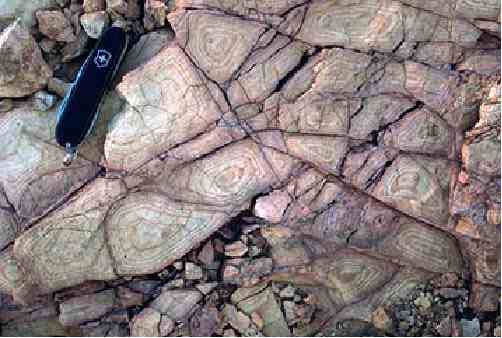
In case of the pictures of these so-called "decorations", they show what are clearly a common geologic feature, Liesegang Banding (rings) which any geologist should have learned about in either their sophomore or junior year in undergraduate school. One example can be seen on the web page, where they have extracts from "the official reports into the excavations at the first known pyramid in Europe" at

http://www.bosnianpyramid.com/index_fil ... rt_en.html

There, it is stated:

"One of the blocks was excavated from a depth of 1.7m.
It was found to have circular patterns which will be
analysed further; it is thought that they are man made."

There is a picture of the circular patterns at:

http://www.bosnianpyramid.com/images/Bo ... sSlabs.jpg

The “circular patterns” in this picture is an undoubted example of natural Liesegang banding (rings). There should be no doubt to any person, who is literate in basic geology, even from a picture, that these circular patterns are natural Liesegang banding, not man-made.

A brief discussion of Liesegang banding (rings) can be found in "Geologic Pattern Formation at

http://wwwitp.physik.tu-berlin.de/~krug/geol_en.html

and in "Stone Images" at

http://www.pgi.gov.pl/pgi_en/index.php? ... le&sid=109

Some pictures of Liesegang banding for comparison, can be found in (1.)
"Liesegang Rings" at

http://www.huddersfieldgeology.supanet. ... /ring1.jpg and

http://www.huddersfieldgeology.supanet. ... 20envi.htm

(2.) "Liesegang banding in Tapeats Sandstone, Deer Creek, mile 136.3. at:

http://www.aapg.org/slide_bank/grand_canyon/72.cfm

(3.) "Fracture-controlled Liesegang banding in siltstone" at:

http://darkwing.uoregon.edu/~millerm/7LM20.jpeg and

http://darkwing.uoregon.edu/~millerm/minfracs.html

(4.) " Liesegang banding in Unkpapa Sandstone, Calico Canyon, Black
Hills, South Dakota" at

http://www.geodil.com/images/18/1800/mid.jpg and

http://www.geodil.com/image.asp?ImageID ... egoryid=20

A simple definition of Liesegang Banding (Rings) is:

"1. Secondary, nested rings or bands caused by
rhythmic precepitation within a fluid saturated
rock (AGI, 1983). 2. A small-scale, more or less
concentric, chemical reaction effect, seen as
discrete, but largely contiguous, structures
throughout a part of a rock body. Each structure
shows, on an exposed surface, ring-shaped bands
of concentric colour. The effect is probably caused
by rhythmic precipitation in a gel (a jelly-like
colloidal solution), perhaps a kind of weathering
process........... (Wyatt, 1992)."

Wyatt, A., 1992.. Challinor's Dictionary of Geology.
Cardiff, Wales: University of Wales Press.

Some References About Them are:

Fu, L., Milliken, K. L., Sharp, J. M., Jr, 1994, Porosity
and permeability variations in fractured and liesegang-
banded Breathitt sandstones (Middle Pennsylvanian),
eastern Kentucky; diagenetic controls and implications
for modeling dual-porosity systems. Journal of
Hydrology. vol. 154, no. 1-4, pp. 351-381.

Ortoleva, P. J., 1983, The self organization of liesegang
bands and other precipitate patterns. In G. Nicolis-G and
F. Baras, eds., pp. 289-297, Chemical instabilities;
applications in chemistry, engineering, geology, and
materials science. NATO ASI Series. Series C:
Mathematical and Physical Sciences. no. 120; D. Reidel
Publishing Company. Boston.

Shahabpour, J., 1998, Liesegang blocks from sandstone beds
of the Hojedk Formation, Kerman, Iran. Geomorphology.
vol. 22, no. 1, pp. 93-106.

Yours,

Paul H.
Last edited by Paul H. on Mon Jun 12, 2006 10:04 am, edited 4 times in total.
Paul H.
Posts: 30
Joined: Fri Jun 09, 2006 6:42 pm
Location: Louisiana

Post by Paul H. »

f9 wrote:No one is disputing that this material is sandstone bedrock from the lake wich have existed in the area and blocks of brecia.Geologists who work on the location have constantly claimed same plus that this material have been workout in the form from human activity.And for sandstone bedrocks that is tricky question mostly because this material have been used from humans in exactly same way how have been found in Moon pyramid.Then there are probably geomorfological changes wich have rised sandstone pavements .
Actually, this is not true. At one time, the supporters of Viocica Hill being a real pyramid claimed that sandstone was not native to the area in which it is located. Now we find that this area is underlain by huge quantites of it.

The problem is that the vast majority of the blocks claimed to be man-made are quite clearly not man-made. There is nothing tricky about making this judgement from the innumerable pictures, which have now been posted to Internet of these pseudo-blocks.

One classic example of such a misidentification is the below picture:

Image

Given other pictures, which clearly show one layer of block going under intact, stratified bedrock in the sides of this "excavation", it is quite clear that both layers are nothing more than jointed bedrock. In the above picture, a second layers of jointed bedrock, on which the person is standing, can be seen underlying the upper one. The only thing that statements by the geologists, who claim that these are man-made blocks, prove is that they are exercising the same level of scohlarship and judgement as degreed the geologists, i.e. Dr. Steven Austin, Dr. Harold Coffin, and Dr. Andrew A. Snelling, who are Young Earth creationists, who claim the Earth is only 6,000 - 10,000 years old. If one of them gave a paper or poster at a Geological Society of America (GSA) meeting stating that these are man-made blocks, only the politeness of geologists would prevent them from being openly laughed at.

The above is a frank, undiplomatic, and blunt statement. It is appropriate in case of photographs such as:

Image

These blocks, which are alledged to be man-made, exhibit well-defined ripple marks, which are absolutely natural in origin, on their surface. Even worse, the sets of ripple marks match across the joints separating individual blocks indicating that they are clearly in place. Even if naturally jointed bedrock had been been dug up and used unmodified to built a pavement for an artificial structure, people constructing a man-made structure are not going to carefully reassemble the blocks in exactly the same position as they were taken out of the ground such that the sets of ripple marks on one block align with and even match the set of ripple marks on the adjacent block as the above picture shows.

I have seen one or two pictures of man-made blocks. However, given the presence of Roman and other structures on Viocica Hill, eventually a few pictures would be taken of something, which is actually man-made.

Yours,

Paul H.
f9
Posts: 57
Joined: Sat Apr 29, 2006 4:00 pm

Post by f9 »

I agree with you,confusion have a base for sandstone pavements wich have been widely used in the Balcan region for pavements mostly folowing
ripple marks.I personaly have seen builded pavements wich have been done with care and they have exactly same look like picture above,but have been made in 1920s from stone from some Bosnian quarry.Probably these are natural phenomena here because of sedimentary layers wich can be seen in the cut above pavement.
Locked