No, I'm sorry. If these are the same hill-
www.bosnianpyramid.com/Excavations_files/image618.jpg
http://www.piramidasunca.ba/news/150606 ... nca-05.jpg
I obviously need new glasses.
Bosnian pyramids, Part II, no photos please!
Moderators: MichelleH, Minimalist, JPeters
-
stellarchaser
- Posts: 225
- Joined: Tue Jun 06, 2006 12:17 pm
Yes, Stan is right 100%; those are evergreen trees (darker ones). I'm sorry that I don't know english names/words for it.stan wrote:
Yes, Minimilist, I do study trees.
The color pattern you see on those Bosnian hills is typical of
the differences between deciduous and evergreen trees (obviously I don't know what species).
Those pictures were taken in the spring, when deciduous trees are especially light in color. They darken through the summer.
it is same hill,No, I'm sorry. If these are the same hill-
www.bosnianpyramid.com/Excavations_files/image618.jpg
http://www.piramidasunca.ba/news/150606 ... nca-05.jpg
I obviously need new glasses.
-
Minimalist
- Forum Moderator
- Posts: 16046
- Joined: Mon Sep 26, 2005 1:09 pm
- Location: Arizona

"The Hills are alive........with the Sound of Music......."
Something is wrong here. War, disease, death, destruction, hunger, filth, poverty, torture, crime, corruption, and the Ice Capades. Something is definitely wrong. This is not good work. If this is the best God can do, I am not impressed.
-- George Carlin
-- George Carlin
Re: reply
URL deletedzagor wrote:That is the same hill, just different angle that photograph is taken.RK Awl-O'Gist wrote:Ciko,
I'm not suggesting YOU did it deliberately, but that really doesn't look like the reverse slope of the same hill.
URL deleted
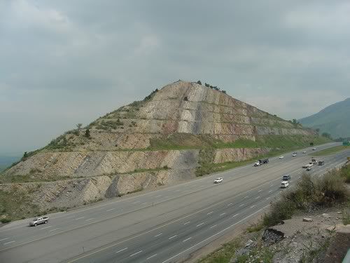
As a geologist, in this picture, the hillslope on the left side of the picture has an uncanny resemblance to the dip slope of a steeply dipping bed. I would suspect the resemblance of this side of the hill to a dip slope has something to do with this side of this hill corresponding precisely in location, dip, and strike to the limb (side) of a known anticline, which is shown on a 1:10,000 scale geologic map of the area.
The origin of dip slopes is described in Dip slope From Wikipedia, the free encyclopedia” at:
http://en.wikipedia.org/wiki/Dip_slope
A picture of the side view of the "Dip Slope of Sill" by Duncan Heron, at Edinburgh, Scotland is at:
http://www.env.duke.edu/eos/geo41/ims067.gif
(from http://www.env.duke.edu/eos/geo41/ims2.htm )
Compare the below picture of a known dip slope at:
http://www.fhsu.edu/geo/neuhauser/SurfinDipSlope.jpg
(from http://www.fhsu.edu/geo/neuhauser/camppg2004.html ),
with alleged facing stone exposed on in excavations at:
http://www.bosnian-pyramid.com/gallery/ ... zidsun.JPG
Also, compare the picture of another documented dip slope:
http://earth.leeds.ac.uk/assyntgeology/ ... g/erratics
(from http://earth.leeds.ac.uk/assyntgeology/classic/quinag/ ),
with
1. http://www.bosnian-pyramid.com/gallery/ ... 3zido2.JPG and
2. http://www.bosnian-pyramid.com/gallery/ ... 020573.jpg
Also, compare
http://www.bosnian-pyramid.com/gallery/ ... skop10.jpg
with
Sandstones
http://www.st-andrews.ac.uk/~www_sgg/ge ... strata.jpg
(from http://www.st-andrews.ac.uk/~www_sgg/ge ... tones.html )
Best Regards,
Paul H.
-
Guest
Re: reply
I'm going crazy looking at those two pictures and trying to find out if it's the same hill or not. They don't look the same, but who knows, maybe the first one's been taken from a weird angle... anyway, the roads trees houses... don't seem to match.RK Awl-O'Gist wrote:No, I'm sorry. If these are the same hill-
www.bosnianpyramid.com/Excavations_files/image618.jpg
http://www.piramidasunca.ba/news/150606 ... nca-05.jpg
I obviously need new glasses.
Re: reply
Dip slopes are quite common in my country, so when I first saw thisPaul H. wrote:
As a geologist, in this picture, the hillslope on the left side of the picture has an uncanny resemblance to the dip slope of a steeply dipping bed. I would suspect the resemblance of this side of the hill to a dip slope has something to do with this side of this hill corresponding precisely in location, dip, and strike to the limb (side) of a known anticline, which is shown on a 1:10,000 scale geologic map of the area.
The origin of dip slopes is described in Dip slope From Wikipedia, the free encyclopedia” at:
http://en.wikipedia.org/wiki/Dip_slope
http://www.bosnian-pyramid.com/gallery/ ... 020573.jpg
I thought I had already seen something like that but couldn't remember exactly where or when. It probably was on a trek around my town
Is it common to find so many geological features at the same place? are those tessellated pavements associated to dip slopes? and the spherical concretions? I understand that they are all related to sedimentari strata, but is there something else?
And BTW, here we also have sedimentary funky-looking mountains
http://upload.wikimedia.org/wikipedia/c ... tery01.jpg
http://es.wikipedia.org/wiki/Imagen:Mun ... serrat.jpg
Probably the best description what is below Visocica is this:
http://i5.photobucket.com/albums/y163/c ... oadcut.jpg
http://i5.photobucket.com/albums/y163/c ... oadcut.jpg
Definitely looks like the same hill to meCiko wrote:it is same hill,No, I'm sorry. If these are the same hill-
www.bosnianpyramid.com/Excavations_files/image618.jpg
http://www.piramidasunca.ba/news/150606 ... nca-05.jpg
I obviously need new glasses.i am 500 % sure that it is same hill , ask anbody here they will confirmed it
In the first picture you can see a path running up from the buildingb to a small darker area towards the middle of the hill. The same path running to the same feature appears in the second picture.
The first picture would have been taken by the trees visible to the right of the buildings in the second picture (ie on the right hand edge of the picture)
-
stellarchaser
- Posts: 225
- Joined: Tue Jun 06, 2006 12:17 pm
dear friends, I just read interesting article of farewell visit to Visoko mayor of Mr. Barakat and Mrs. Lamiya El Hadidi, two egyptian experts so many times mentioned here before. They finished their work here. I would like to underline that this was just the visit to Visoko mayor, and NOT official presentation of the findings.
But I'm sure you're keen to know their opinion about the excavations. I have translated some of their words, so that you get some feeling.
BARAKAT:
"My general view is that Visochica Hill region is very interesting region geologically. By all means, it has to examined (researched) by international team of geological experts. And secondly, it's definite that on the Pyramid of the Moon we have large archeological site, that must be researched on large scale".
HADIDI:
"Different scientists must join in this research: geologists, geopsysicists, archeologists, botanics...at the moment we have just a few real archeological artefacts here, so we need more time to find more of them. As for the man-made structures, we have one or two excellent proofs about them, but far more such structures could be found too. It is neccessary that one database is established.
Beside archeologists, here we need more geologists, who would determine what is natural, and what is man-made. Last discovery on the pyramod of the moon is definitely man-made, but we haven't finished work there , so we can't date that finding that at this moment.
We need more time for research."
So, excuse my bad english and I hope you'll get at least some picture. Again, this was courtesy faravell visit to Visoko town mayor, not official statement.
Last edited by stellarchaser on Fri Jun 23, 2006 4:27 am, edited 2 times in total.
I dont know what a discusion are going for nothing?.It is the same hill,and Mr Sam have been theorising that this side of the pyramid have been eroded.So media have publicised that side which have been most looking like pyramid.There are recognisable remains of the old city on the top of the hill.On both pictures on the right side below the road there are 8 trees +1 big tree near two fields.On one picture field it is with some smoll green crops shooted in early summer and on another it is brown coloured fields probably shot in the early spring.Second road from right to left is going around smoll half circle bunch of trees.And edge of the forest is in same line in both of the pictures.One is areal picture and another is land made picture.End.