Apparently the town is San Javier in Spain.
Here are some of the comments from the original posting...
i'm betting it's some sort of fish, crab, lobster, or some other edible sea animal nursery. i've seen these sorts of things other places, not in google earth, but in national geographic, and others...
Posted by: bob k at February 8, 2007 9:09 AM
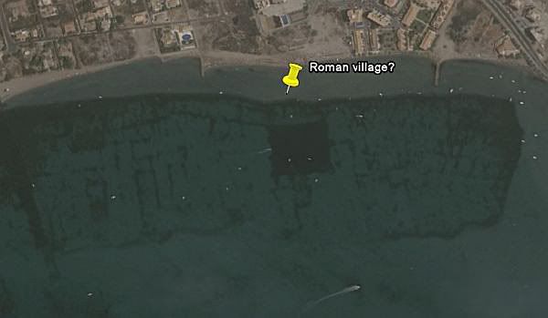
I don't think this could be submerged architecture. First, there's the channel leading to the manmade harbor that looks like it passes through the north end of the 'structures'. It could be that these are remnants of the dredging that created the harbor structure that the canal leads to. Second, if that were a roman ruin, it's huge. Ancient cities that are a kilometer long would have been major settlements and, if lost, would have been the target of searches before now. Finally, I spent a summer documenting Aperlae, an underwater city on the southern coast of Turkey (36.158 N 29.783 E). There are significant structures, churches, tanks, bathhouses, at 1-2 meters depth that are undetectable in similar resolution DigitalGlobe imagery. Makes me very skeptical that the feature on the Spanish coast could be a submerged city.
Posted by: Kristopher Larsen at February 8, 2007 12:51 PM
What in the world is in the middle of that thing above it. Looks kind of like an airport or something.
Posted by: David Ogletree at February 8, 2007 5:54 PM
Yes. looks like a submerged village/city.
Who ever the engineer/planner was who designed that Y-shaped housing development to the northeast should have their license pulled. It's design boggles the mind!
Later...
Posted by: ornithologist at February 9, 2007 1:45 AM
It could simply be a mussel nursery. See similar (although probably more modern) site there :
http://maps.google.fr/maps?f=q&hl=fr&q= ... iwloc=addr
Posted by: reb at February 9, 2007 4:12 AM
When I saw this picture for the first time, I immediately thought these tracks were the result of dredging.
See also
http://en.wikipedia.org/wiki/Dredge
As I read that the water was very shallow here, I was quite sure that I'm right.
Posted by: Ernst M. Kofler at February 9, 2007 7:36 AM
Indeed, that could be from Roman times, though no sunken city but salt exploitation. See "
http://www.statravel.com.au/cps/rde/xch ... 078_en.xml"
Cheers, tinbert
Posted by: tinbert at February 10, 2007 4:33 AM
There is also what look like structures underwater in a place calle Salar De Surire lake in northern chile. it is a salt flat and i've been trying to figure this out for days now. if there are any artifacts under the water they would be emaculately preserved because of the salt content of the water.